|
|
|
|
| Missing In Action (MIA) | Prisoners Of War (POW) | Unexploded Ordnance (UXO) |
| Chronology | Locations | Aircraft | Ships | Submit Info | How You Can Help | Donate |
|
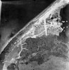 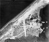 528th BS Dec 21, 1943 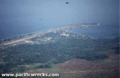 Richard Leahy 1994 |
Location Lat 3° 20' 53S Long 128° 55' 34E Amahai Airfield is located at Amahai in the Molucca Islands (Maluku). Also known as "Amahai Drome". To the south is Seram (Ceram). Prewar and during the Pacific War located in the Netherlands East Indies (NEI). Today located in Maluku Province (Provinsi Maluku) in Indonesia. Wartime History Used by the Japanese as a wartime airfield. Between December 1943 until December 1944 attacked by Allied aircraft and neutralized from the air. Occupied by the Japanese until the official surrender of Japan in September 1945. American missions against Amahai December 21, 1943–December 13, 1944 On July 28. 1944 near Amahai, Charles A. Lindbergh was flying a P-38J Lightning as an 'observer' with the 475th Fighter Group "Satan's Angels" (475th FG), 433rd FS and shot down a Ki-51 Sonia piloted by Shimada during a head on pass. Today Still in use today as Amahai Airport. Airport codes: ICAO: WAPA, IATA: AHI. References Index to Air Bases - Research Report No. 85, I.G. No 9185 - July 30, 1944 Contribute
Information Last Updated
|
Map Fallingrain View in Google Earth |
| Discussion Forum | Daily Updates | Reviews | Museums | Interviews & Oral Histories |
|