|
|
|
|
| Missing In Action (MIA) | Prisoners Of War (POW) | Unexploded Ordnance (UXO) |
| Chronology | Locations | Aircraft | Ships | Submit Info | How You Can Help | Donate |
|
 22nd BG c1944 |
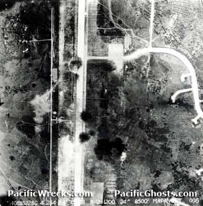
Location Lat 1° 32' 58N Long 124° 55' 33E Mapanget Airfield is located at an elevation of 264' above sea level seven kilometers west of Mapanget and thirteen kilometers northeast of Manado (Menado) on the eastern arm of the Sulawesi (Celebes). Also known as "Manado Airfield" or "Manado I". Prewar and during the Pacific War located in the Netherlands East Indies (NEI). Today known as Sam Ratulangi International Airport or Bandara International Airport or Manado International Airport located in North Sulawesi Province in Indonesia. Construction Built by the Japanese, this single runway, had a taxiway with revetments to the side. Wartime History Used by the Japanese Army Air Force (JAAF) as a military airfield. On April 25, 1944 three Ki-43 Oscars (only one servicable) fleeing from Hollandia arrived at Mapanget. During early September 1944 until July 1945 attacked by US bombers and fighters that neutralized the airfield. Occupied by the Japanese until the official surrender of Japan in early September 1945. American missions against Mapanget September 9, 1944–July 14, 1945 Japanese units based at Menado 248th Sentai (3 x Ki-43) Hollandia April 25, 1944 P-38L Lightning Pilot Everhart crashed October 12, 1944 Today Still in use today as "Sam Ratulangi International Airport" or "Bandara International Airport" or "Manado International Airport". Airport codes: ICAO: WAMM and IATA: MDC. The single runway measures 8,691' x 148' surfaced by asphalt orientated 36/18. References Index to Air Bases - Research Report No. 85, I.G. No 9185 - July 30, 1944 Mapanget (Manado I) Sam Ratulangi Manado - Official Website Contribute
Information Last Updated
|
Map Fallingrain |
| Discussion Forum | Daily Updates | Reviews | Museums | Interviews & Oral Histories |
|