|
|
|
|
| Missing In Action (MIA) | Prisoners Of War (POW) | Unexploded Ordnance (UXO) |
| Chronology | Locations | Aircraft | Ships | Submit Info | How You Can Help | Donate |
|
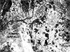 USAAF Nov 23, 1944 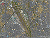 Google Earth Jan 11, 2018 |
Location Lat 35° 15' 18N 136° 55' 28E Komaki Airfield is located at an elevation of 52' above sea level to the south of Komaki in Aichi Prefecture in the Tōkai subregion of the Chūbu Region of central Honshū in Japan. To the north is the Oyama River (Oyama Gawa). To the south is the Shonai River (Shonai Gawa) and beyond Nagoya. Known as Komaki Airfield or spelled Kamake Airfield. Postwar, known as Nagoya Air Base (Nagoya AB). Toda known as "Nagoya Airport" or "Prefectural Nagoya Airport". Construction Built during 1944 by the Japanese Army as as a single runway. Wartime History Used by the Japanese Army Air Force (JAAF) as a military airfield for the defense of the Nagoya area. Units based at Komaki included the 55th Sentai operating the Type 3 Fighter Hein / Ki-61 Tony. Japanese units based at Komaki Airfield (Kamake) 55th Sentai (Ki-61) On January 3, 1945 Ki-61 Tonys from Komaki Airfield took off with other Army and Navy fighters to intercept a formation of 97 B-29 Superfortresses on a bombing mission (Mission 17) against Nagoya and claim five B-29s shot down. During July 1945, P-51D Mustangs attacked Komaki Airfield claiming aircraft in the air and on the ground. American missions against Komaki Airfield January 3, 1945–July 20, 1945 Postwar After the surrender of Japan, Komaki Airfield was occupied by U.S. forces and became known as Nagoya Air Base (Nagoya AB). The Americans began by repairing the airfield and installations for use as a headquarters and military airfield. During May 1946, the Nagoya Air Base became home to Fifth Air Force (5th AF) Headquarters that controlled the U.S. Army Air Force (USAAF) and later U.S. Air Force (USAF) units stationed in Japan. In December 1950 during the Korean War, the Headquarters moved to South Korea. In September 1954, it returned to Nagoya Air Base and remained until July 1957 when moved to Fuchu Air Station west of Tokyo. Operational use from the airfield began in February 1947 when the 347th Fighter Group (All Weather) began operating P-61 Black Widow interceptor aircraft, which were used to provide air defense for Japan. It operated from the airfield until June 1950 when the Black Widows were retired and the unit was inactivated. At the end of the Korean War, the 49th Fighter Group (49th FG) with F-84 Thunderjets moved to Nagoya Air Base and provided air defense until June 1957 when it moved to Misawa Air Base. Contribute
Information Last Updated
|
Map Fallingrain Photo Archive |
| Discussion Forum | Daily Updates | Reviews | Museums | Interviews & Oral Histories |
|