 |
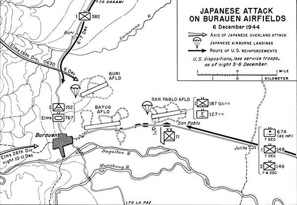
Map of Japanese Attack on Burauen Airfields on December 6, 1944
The map shows the disposition of U.S. forces, less service troops during the night of December 5, 1944 to December 6, 1944 at Buri, Burauen (Burouen, Burauen), Bayug Airfield (Burouen, Burauen) and Buri Airfield. The gray arrows show the axis of advance of Japanese Army attacks by elements of the 16th Division on December 6, 1944 towards Buri Airfield and the 26th Division during the night of December 10-11, 1944 towards Burauen. The parachute icons indicating Japanese paratrooper landings (Operation Te) at Buri Airfield and San Pablo Airfield with the headquarters 11th Airborne Division and 1st Battalion, 187th Glider Infantry Regiment (less) and 127th Infantry Regiment (less). The black arrow indicating the advance of U.S. Army reinforcements from Julita. To the south is the Daguitan River and Marabong River that merge.
Credit: U.S. Army Date: December 6, 1944
Map
High Resolution Version
Acquire This Image |
Contribute Information
Do you have photos or additional information?
Previous Page
|
|