|
|
|
|
| Missing In Action (MIA) | Prisoners Of War (POW) | Unexploded Ordnance (UXO) |
| Chronology | Locations | Aircraft | Ships | Submit Info | How You Can Help | Donate |
|
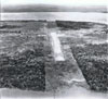 RAAF 1964 |
Location Lat 9° 5' 12S Long 143° 12' 28E Daru Airfield is located on Daru Island off the southern coast of New Guinea. Prewar and during the Pacific War, part of the Western District in the Territory of Papua. Today located in Western Province in Papua New Guinea (PNG). Wartime History Small Allied wartime airstrip, used as part of the ferry route from Horn Island Airfield, to Port Moresby. The offshore area was used as a seaplane landing area. Postwar During 1965, the Australian Army undertook the reconstruction of Daru Airfield. Today Still in use today as "Daru Airport". The runway measures 1,400m x 30m orientation 14 / 32 at an elevation of 13'. Airport codes: ICAO: AYDU and IATA: DAU. References NAA: BP456/2, 1965/68 PART 1 Daru - Reconstruction of airfield NAA: BP456/2, 1965/68 PART 2 Daru - Reconstruction of airfield National Airport Comission (NAC) - Daru Airport Contribute
Information Last Updated
|
Map Fallingrain Photo Archive |
| Discussion Forum | Daily Updates | Reviews | Museums | Interviews & Oral Histories |
|