|
|
|
|
| Missing In Action (MIA) | Prisoners Of War (POW) | Unexploded Ordnance (UXO) |
| Chronology | Locations | Aircraft | Ships | Submit Info | How You Can Help | Donate |
|
 USAAF c1942 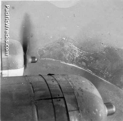 Frances Lasker c1947  Andrew Wright 1994  Justin Taylan 2005  Justin Taylan 2005  U.S. Army November 1942 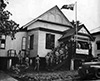 Australian Army 1943  Justin Taylan 2005  Sakaguchi 2004 |
Location Lat 9° 28' 60S Long 147° 10' 60E Port Moresby is located on the southern coast of New Guinea on a peninsula that includes Paga Hill, Ela Beach and the wharf area on the southern coast of New Guinea. Borders Fairfax Harbor to the northwest and Walter Bay to the southeast. Prewar and during the Pacific War located in the Territory of Papua. Today located in the National Capital District (NCD) in Papua New Guinea (PNG). Also known as simply "Town" or "Moresby". In Tok Pisin spelled "Pot Mosbi" or simply "Mosbi" and abbreviated as "POM". Prewar Port Moresby was a small administrative center for the Australian territories of Territory of Papua and Territory of New Guinea. Wartime History During the Pacific War, Port Moresby was the strategic objective of the Japanese on two occasions. First, in early May 1942 during the Battle of Coral Sea and second in late September 1942 during the Japanese Army advance over the Kokoda Trail in the Owen Stanley Range. Starting in late January 1942 until late September 1943 Port Moresby was targeted by Japanese aircraft and was subjected to over one hundred bombing attacks. Most attacks targeted Allied shipping, airfields and military installations. U.S Army code name "Teak". Japanese missions against Port Moresby January 28, 1942–September 20, 1943 During 1942-1944, the Port Moresby area was developed into a major Allied staging area and airfield complex to support the Allied offensive in New Guinea. Occupied by both Australian and American personnel. Designated "Base D" as the US Army Letter Base designation and U.S. Army Post Office 929 (APO 929). Today Port Moresby is the national capital of Papua New Guinea (PNG). The town has grown into a city and many traces of the war have been removed or disappeared. To this day, wartime Marston Matting / PSP (Pierced Steel Planking) is still used as fences, sidewalks or animal pens. During the late 1970s PNG War Museum Museum and had a large collection of war relics and artifacts that are today in storage or a small selection displayed at the National Museum and Art Gallery (NMAG). Burns Philp Building Built prewar, overlooks the wharf area and survived the war undamaged, across from the Papuan Hotel. During late 2005 burned down and rebuilt with the original facade. Papuan Hotel This prewar hotel was taken over by American forces and used as a HQ. It survived the war, Burned down during the 1960s. Troops Club Located in Port Moresby town, operated by the U.S. Canteen Services. Today is near the present day Crown Plaza Hotel. Port Moresby Masonic Lodge (Lodge No. 292) On September 30, 1922 established by A .W. Woolfrey on Port Road. During 1941, closed due to the Pacific War. During late 1942, a member of RAAF No. 30 Squadron held a meeting in June Valley. On September 4, 1944 the lodge reopened. During 1955, relocated to a new building, across from the Crown Plaza Hotel where it remains to this today. The lodge has painted RAAF, AIF and 5th Air Force logo from the war on display. Embassy of the United States - Papua New Guinea The United States Embassy in Papua New Guinea (U.S. Embassy PNG) is located on Douglas Street in Port Moresby. This embassy covers U.S. relations with Papua New Guinea (PNG), Solomon Islands and Vanuatu. Inside the lobby of the Embassy is the "Marker at Papua New Guinea" a bronze plaque dedicated November 6, 1992 on the 50th anniversary of the arrival of General Douglas MacArthur in the South West Pacific Area (SPWA). This plaque is maintained by American Battle Monuments Commission (ABMC) requires entry into the lobby of the embassy. U.S. Embassy in Papua New Guinea, Solomon Islands and Vanuatu American Battle Monuments Commission (ABMC) Marker at Papua New Guinea Library Built prewar on Douglas Street in Port Moresby. This building survived the war undamaged and remains to this day. Port Moresby (Town) Locations Ela Beach located at the southern edge of Port Moresby bordering Walter Bay. Koki (2 Mile) located to the east of Port Moresby, today located in Moresby South. Kila Kila (3 Mile) located to the east of Port Moresby site of 3 Mile Drome (Kila Kila Drome) the first airfield. Waigani (5 Mile) located to the north of Port Moresby site of Ward Drome (5 Mile Drome) and PNG Parliament. Gordon located to the southeast of Waigani formerly PNG Museum Modern History (War Museum). Konedobu (Kanedabu) located to the north of Port Moresby prewar Port Moresby Flying Boat Base. Kaevaga located to the north of Port Moresby includes the Governor General's Residence used by MacArthur. Hanuabada (Hanuada) village located at the edge of Fairfax Harbor includes Hanabada Point. Boroko located to the east of Port Moresby includes Arcadia, Murry Barracks, 3 Mile, 4 Mile and Taurama. Barune (Barume) dump area located to the north of Port Moresby nearby was the 116th Station Hospital. Gerehu located to the north of Port Moresby includes the University of Papua New Guinea (UPNG). Napa Napa borders Fairfax Harbor across from Port Moresby mooring area for flying boats. Bomana located to the north of Port Moresby includes Bomana War Cemetery and 12 Mile Drome (Berry Drome). Bomana War Cemetery located at Bomana established during 1942 as a Commonwealth War Cemetery. Pari borders Joyce Bay to the southwest of Port Moresby. Port Moresby Mountains, Named Hills, Features and Swamps Paga Hill (Paga Point, Monga Point) feature located at the southwest edge of Port Moresby with gun battery. Tuaguba Hill (Ack Ack Hill) highest elevation feature at the eastern edge of Port Moresby with anti-aircraft guns. Morris Hill (Zero Hill) located near Bootless Bay and 7 Mile Drome. Twin Peaks located near the Laloki River, today being excavated for gravel. Mount Eriama located near the Laloki River along the Sogeri Road outside Port Moresby. Walker Hill located near Port Moresby. Burns Peak located near Konedobu postwar road cut and highway. Mount Lawes (Mt. Lawes, Bisogo) large hill to the north of Port Moresby known as Mount Schwimmer. Little Mount Lawes (Little Mt. Laws) smaller hill near Mount Laws to the north of Port Moresby. Pyramid Point located on the southern coast to the southeast of Port Moresby at the entrance to Bootless Bay. Waigani Swamp (Gavagabada) located to the north of Port Moresby to the east of Gerehu. Port Moresby Harbors and Bays Fairfax Harbor borders Port Moresby to the south and west sometimes referred to as Moresby Harbor. Walter Bay borders Paga Point to the west and Ela Beach and Port Moresby to the north. Joyce Bay borders the southern coast of New Guinea and Pyramid Point to the southeast of Port Moresby. Idlers Bay (Idlers Inlet) located to the west of Port Moresby borders Roku (Raku) and Pah Pah Point. Bootless Bay (Bootless Inlet) located to the southeast of Port Moresby. Oyster Bay located at the western edge of Bootless Bay. Port Moresby Area Offshore Islands and Reefs Tatana Island located at the northeastern edge of Fairfax Harbor. Motukea Island located at the northern edge of Fairfax Harbor. Gemo Island located at the southwest end of Fairfax Harbor. Lolorua Island located at the southwest end of Fairfax Harbor. Fishermans Island (Daugo) located to the south of Fairfax Harbor. Local Island (Manubada) large island located in Joyce Bay off Koki (2 Mile). Scone Island small island located in Joyce Bay off Koki (2 Mile). Haidana Island located off the southern coast of New Guinea off Idlers Bay. Nateara Reef fringing reef south of Port Moresby, Walter Bay, Joyce Bay borders Basilisk Passage. Sinavi Reef fringing reef south of Port Moresby. Basilisk Passage located at the entrance to Fairfax Harbor. Port Moresby Airfields and Seaplane Bases 3 Mile Drome (Kila Drome, Kila Kila Drome) located to the east of Port Moresby built in 1933 and in WWII. Port Moresby Flying Boat Base located at edge of Fairfax Harbor near Port Moresby built in 1939. 5 Mile Drome (Ward Drome) located at Waigani built during 1942 as a bomber and transport strip. 7 Mile Drone (Jackson Drome, Port Moresby Jacksons International Airport) located to the north of Port Moresby. 12 Mile Drome (Berry Drome) located near Bomana built during 1942 as a fighter strip. 14 Mile Dome (Schwimmer Drome, Laloki Drome) located near the Laloki River built during 1942 as a fighter strip. 17 Mile Drome (Durand Drome) located near the Waigani swamp built in 1942 as a fighter and bomber strip. 30 Mile Drome (Rogers Drome, Rarona Drome) located to the northwest built 1942 as a fighter and bomber strip. Fishermans Island Airfield (Daugo Airfield) located on Fishermans Island built 1944 as an emergency strip. Port Moresby Area Gun Batteries and Fortifications Tuaguba Hill Gun Battery located atop Tuaguba Hill (Ack Ack Hill) first anti-aircraft gun battery at Port Moresby. Paga Hill Battery located atop Paga Hill with coastal guns, radar and anti-aircraft guns defending Port Moresby. Gemo Island Battery located on Gemo Island coastal guns to defend the entrance to Fairfax Harbor. Boera Battery located in the hills near Boera to the west of Port Moresby. Bootless Bay Battery located at Kila beach, Stokes Range then Drysdale Ridge defending Bootless Bay. Basalisk Battery located to the northwest of Port Moresby coastal guns defending the approaches. References Wings of Destiny (2008) pages 176 (map), 178 (Port Moresby) "[Port Moresby] town was set against olive green hills, overlooking a blue green harbor and the 'T' shaped wharf. In 1941 the town had a population of 400 Europeans and 1000 Melanesians. By early 1942, most of the civilians had evacuated. The shops and hotels were closed and any buildings not damaged by the Japanese bombing was taken over by the military. The town offered virtually no amenity to the airmen." Contribute
Information Last Updated
|
Map 1942 Map 1943 Map Fallingrain |
| Discussion Forum | Daily Updates | Reviews | Museums | Interviews & Oral Histories |
|