|
|
|
|
| Missing In Action (MIA) | Prisoners Of War (POW) | Unexploded Ordnance (UXO) |
| Chronology | Locations | Aircraft | Ships | Submit Info | How You Can Help | Donate |
|
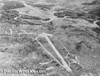 USAAF c1942  Justin Taylan 2003 |
Location Lat 9° 23' 19S Long 147° 13' 22E Bomana is located at an elevation of roughly 830' / 252m above sea level inland from the southern coast of New Guinea. Roughly 12 miles to the south is Port Moresby. Prewar and during World War II located in the Territory of Papua. Today located in the National Capital District (NCD) of Papua New Guinea (PNG). 12 Mile Drome (Berry Drome) Built during 1942 and used as a fighter airstrip until 1943 B-26 "Diana's Demon" 40-1495 Pilot Seffern crashed January 10, 1943 during take off on the Bomana side of the Laloki River. Bomana War Cemetery (Port Moresby War Cemetery) Commonwealth cemetery Bomana Japanese War Cemetery Japanese cemetery near Bomana closed postwar Contribute
Information Last Updated
|
Map Fallingrain Photo Archive |
| Discussion Forum | Daily Updates | Reviews | Museums | Interviews & Oral Histories |
|