|
|
|
|
| Missing In Action (MIA) | Prisoners Of War (POW) | Unexploded Ordnance (UXO) |
| Chronology | Locations | Aircraft | Ships | Submit Info | How You Can Help | Donate |
|
 Tracy February 28, 1940 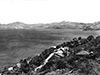 Fisher August 18, 1942  USAAF c1942  Grimes May 29, 1943  Justin Taylan 20004 |
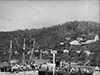
Location Fairfax Harbor is located to the south of Port Moresby in the southern coast of New Guinea. Borders Paga Hill (Paga Point, Monga Point), Hanabada (Hanuada) and Napa Napa. Also spelled Fairfax Harbour. The area of the harbor nearest to Port Moresby (Town) is sometimes referred to as "Moresby Harbor" or "Port Moresby Harbor". Fairfax Harbor includes Tatana Island and Motukea Island. To the west is Idlers Bay and to the west is Walter Bay, Joyce Bay and Bootless Bay. Outside Fairfax Harbor to the southwest is Gemo Island and Lolorua Island. Further to the south is Nateara Reef and beyond the Coral Sea. Prewar and during the Pacific War part of the Territory of Papua. Today located in the National Capital District (NCD) of Papua New Guinea (PNG). Prewar Fairfax Harbor was the primary anchorage and port for the Territory of Papua. During the 1930's used by flying boat and seaplanes including Qantas Airlines and the Royal Australian Air Force (RAAF). Fairchild 91B / Model XR-942-B "Kono" Registration NR777 Sunk during 1936 during a tropical storm Wartime History During the Pacific War, Fairfax Harbor was an important port supporting the Allied war effort in New Guinea. During 1942, the harbor was bombed by the Japanese sinking several ships and aircraft sunk. The harbor was defended by Australian gun batteries on Paga Hill and Gemo Island Battery an anti-submarine net and mine fields. Port Moresby Flying Boat Base (Qantas Flying Boat Base) Prewar flying boat base used by RAAF flying boats during the war and postwar. Disused since 1966 when Qantas discontinued service. PBY Catalina Serial Number A24-5 Sunk April 24, 1942 at its moorings after Japanese bombing raid Tatana Island Island inside Fairfax Harbor. American forces built a causeway to the mainland. The causeway was built by a U.S. Army 96th Engineering Battalion (Colored) African American Negro soldiers During the war, Liberty Ships docked at the island and were unloaded. The causeway was one vehicle wide. Post war, this causeway has been widened. Wharf Built prewar and operated by Burns Philips, the wharf that connects Port Moresby to Fairfax Harbor. During the war, the wharf was pressed into service as the only wharf available, until a causeway was built to Tatana Island. The wharf was targeted by Japanese bombers including film by Damien Parer showing it being hit with 60kg bombs. On June 20, 1943 a detachment of 70 U.S. Navy (USN) 55th Naval Construction Battalion (55th NCB) "Seabees" sarrived to direct the wharf and later were augmented by a detachment from Milne Bay. Seabees directed harbor operations, built a radio station, port headquarters and ten Quonset huts for living quarters, water supply and storage, generator and transmitter buildings that went into operation by July 15, 1943. By January 12, 1944, eight additional Quonset huts were built and by July 1944, nineteen more Quonset huts were added. On April 3, 1944 CBMUU 546 arrived to relieve the Seabees. In October 1944 base roll-up was initiated and completed by November 1, 1944. The wharf is still in use today as a commercial port for container ships and cargo vessels. Napa Napa Located across from Port Moresby, bordering Fairfax Harbor. MV MacDhui Sunk June 18, 1942 damaged by Japanese bombing and ran aground and sank A-20G Havoc Serial Number 43-9626 Pilot Jesser crashed March 18, 1944 crashed near Motukea Island, 2 missing Ammunition Dump At the end of the war or due to accidental dumping during the war, small arm ammunition dump (.303, 30 and 50 caliber) rounds in wooden boxes were dumped into Fairfax Harbor near Napa Napa. In 2004, the site was discovered by locals that were free diving to it to recover rounds to set off as fireworks and sell the brass as scrap metal. Today, some boxes remain on the muddy bottom. Contribute
Information Last Updated
|
Map 1942 Map 1943 Photo Archive |
| Discussion Forum | Daily Updates | Reviews | Museums | Interviews & Oral Histories |
|