|
|
|
|
| Missing In Action (MIA) | Prisoners Of War (POW) | Unexploded Ordnance (UXO) |
| Chronology | Locations | Aircraft | Ships | Submit Info | How You Can Help | Donate |
|
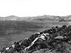 Fisher August 18, 1942  Justin Taylan 2007 |
Location Lat 9° 28' 4S Long 147° 8' 54E Konedobu is located at an elevation of 36' / 10m above sea level to the north of Port Moresby (Town) along the shore of Fairfax Harbor to the south and Hanabada and Kaevaga to the northwest. To the north is Burns Peak. Also known as "Kanedabu". The inland hill is known as Konedobu Hill. Today located in National Capital District (NCD) in Papua New Guinea (PNG). Wartime History During the war, the Konedobu area was an Australian camp and hospital area known as "Konedobu Camp". The Royal Australian Air Force (RAAF) had a hospital and camp area at Konedobu. Royal Papuan Yacht Club (Port Moresby Yacht Club) Prior to the Pacific War, this location was just west of the Port Moresby Flying Boat Base. The present day Yacht Club is partially formed by land fill. In 1971 the mast from MV Macdhui was placed as a memorial outside the club with memorial plaques. Burns Peak Peak located in this area. A road cut was made into this feature to allow for the modern freeway to be built. B-24J Liberator Serial Number 42-100205 Pilot Laurie crashed March 12, 1944 Contribute
Information Last Updated
|
Map 1943 Map Fallingrain |
| Discussion Forum | Daily Updates | Reviews | Museums | Interviews & Oral Histories |
|