|
|
|
|
| Missing In Action (MIA) | Prisoners Of War (POW) | Unexploded Ordnance (UXO) |
| Chronology | Locations | Aircraft | Ships | Submit Info | How You Can Help | Donate |
|
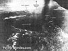 USAAF April 22, 1943 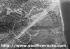 USAAF c1944 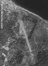 USAAF July 24, 1945 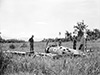 Australian Army October 30, 1945 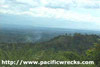 Justin Taylan 2000 |
Location Lat 4° 18' 33S Long 152° 0' 44E Keravat Airfield was located to the south of Keravat (Keravat Experimental Station, Keravat Government Experimental Farms) near the western coast of the Gazelle Peninsula of New Britain. To the north is Keravat Plantation, to the northeast is Tavilo Plantation, to the south is the Keravat River and Keravat. Beyond to the east is Rabaul. Wartime spelling "Kerevat Airfield", "Keravat Airfield" or "Karavat Airfield". Also known as "Tavelo Airfield". Between 1884 until September 1914 part of Deutsch Neu Guinea (German New Guinea). Prewar and during the Pacific War part of the Territory of New Guinea. Today located in East New Britain Province in Papua New Guinea (PNG). Prewar Keravat Plantation and Tavilo Plantation were established at this location planted with coconut palms harvesting copra. To the southeast is Keravat (Keravat Experimental Station, Keravat Government Experimental Farms). Construction During September 1943, the Japanese began construction of a single runway measuring 4,800' oriented roughly east in Keravat Plantation. Wartime History Kerevat Airfield had serious water drainage issues that made flight operations difficult. Due to the drainage problems, Kerevat Airfield was only used to a limited capacity for flight operations and as a crash strip. Japanese units based at Kerevat 552 Kokutai (D3A2 Val) arrives December 18, 1943–January 25, 1944 departs Truk Allied missions against Kerevat Airfield June 20, 1943–May 16, 1944 Todays Abandoned as an airfield since the war. The outline of the former runway is still visible from a distance. A6M Zero Force landed and abandoned at Keravat Airfield Contribute
Information Last Updated
|
Photo Archive May 26, 1943 Map Fallingrain View on Google Earth |
| Discussion Forum | Daily Updates | Reviews | Museums | Interviews & Oral Histories |
|