Missing In Action (MIA)
Prisoners Of War (POW)
Unexploded Ordnance (UXO)
Chronology
Locations
Aircraft
Ships
Submit Info
How You Can Help
Donate
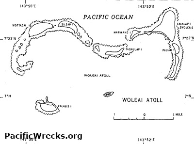
Map of
Woleai Atoll
surrounded by the Pacific Ocean
Bordering
East Lagoon
is
Tagaulap Island
,
Mariyang Island (Mariaon)
,
Woleai Island (Falalap)
,
Paliau Island
and
Raur Island
.
Bordering West Lagoon is Wottagai Island, Sileap Island.
To the south is Motegosu Island and southwest is Falalis Island.
Credit: USN Date: 1944
Map
High Resolution Version
Acquire This Image
|
Contribute Information
Do you have photos or additional information?
Previous Page
Discussion Forum
Daily Updates
Reviews
Museums
Interviews & Oral Histories
Pacific Wrecks Inc.
All rights reserved.