|
|
|
|
| Missing In Action (MIA) | Prisoners Of War (POW) | Unexploded Ordnance (UXO) |
| Chronology | Locations | Aircraft | Ships | Submit Info | How You Can Help | Donate |
|
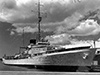 USCG 1940 |
Location Honolulu Harbor borders Honolulu on southern Oahu and borders Sand Island to the south and west. Also known as Kulolia or Ke Awa O Kou in Hawaiian. Also known as the Port of Honolulu. Prewar and during World War II part of the Territory of Hawaii. Today part of Honolulu County in the State of Hawaii in the United States. Wartime History On December 7, 1941 in the morning USCGC Taney was moored alongside pier 6 in Honolulu Harbor. At 7:55am received word of the Japanese attack and four minutes later manned her guns and prepared to get underway. When Japanese planes were spotted over Honolulu Harbor, engaged with gunfire from her 3" deck gun and .50 caliber machine guns causing them to change course. During the attack, some of her crew were ordered to defend the Aloha Tower in Honolulu. On December 8, 1941 at 5:46am USCGC Taney departs to patrol approaches and returns six days later. In the aftermath of the Japanese attack, the U.S. Navy (USN) held ships in Honolulu Harbor to assess the threat of further Japanese attacks. After a week, ships were released or rerouted if necessary. For the remainder of the Pacific War, Honolulu Harbor was used by commercial and military vessels. Today Honolulu Harbor is administered by the Hawaiʻi Department of Transportation Harbors Division and handles over 11 million tons of cargo annually. References State of Hawaii Department of Transportation Harbors Ka ʻOihana Alakau Contribute Information Do you have photos or additional information to add? Last Updated January 3, 2026 |
Map Mapcarta |
| Discussion Forum | Daily Updates | Reviews | Museums | Interviews & Oral Histories |
|