Visit to Iwo Jima 1995
by Sean Prizeman
Background
In 1995, I visited Iwo Jima with the
50th Anniversary rememberances. I've been interested in WWII since I was a boy.
Growing up in Southern California, I came in contact with several WWII
Marine veterans, many of whom shared their experiences of the Pacific
War. I suppose my "specializing" in the PTO was due to the
nature of the Pacific itself, with its vast oceans and tropical islands,
but also the nature of the combatants themselves: one adversary that
would fight to live and another that would fight to the death (an extreme
clash of cultures and ideologies one might say).
I have been fortunate to travel to Guam, Saipan,
Tinian, Iwo Jima and Peleliu. I became especially interested in traveling
to Iwo after viewing the documentary on the 40th anniversary of Iwo
Jima entitled, Return to Iwo Jima. Like anyone who has a serious interest
or a passion, you also develop contacts that lead you from one opportunity
to another. After receiving a flyer from a military tours group about
an upcoming trip to Iwo, and knowing how difficult it would be to go
any other way, I jumped at the chance.
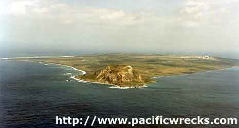
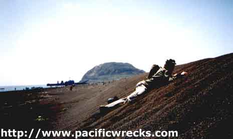
Iwo Jima: First Impressions
Having seriously studied the battle of Iwo Jima
for the past 20 years, I had the island's topography well pictured in
my mind. As
we approached the island, the plane banked allowing us to see the silent
cone of Mt. Suribachi at the island's tip still standing guard 50 years
later. It was incredible to look out the window and actually see the
site where so many had died, a remote speck now considered hallowed
ground by both Americans and Japanese.
After exiting the plane onto the tarmac, I was greeted
by the strong smell of sulphur, which quickly reminded me of the volcanic
nature of the island beneath my feet. From the soft volcanic rock the
Japanese had carved some of the most ingenious and impregnable defenses
encountered by the U.S. Marines in WWII. Instead of the shell-pocked
moonscape as typified in movies and photos taken during the battle,
Iwo had a green covering of shrubs and grasses which now covered much
of the island, including the former airfield known as Motoyama No. 1.
Our plane was the first commercial jet aircraft
ever allowed to make a landing on Iwo, which is today Japanese military
installation, and next to impossible to visit, except under special
circumstances such as this 50th anniversary reunion. The island was
a U.S. territory under military control until it was returned to Japan
in 1968. The last American presence, a Coast Guard unit, left the island
permanently in October, 1993.
Because of its status as a military base as part of
the Japanese SDF, it is quite difficult to obtain permission to visit
the island. On another level, the Japanese consider Iwo to be their
Arlington, a sacred place not open to the outside world, and only begrudgingly
to their former adversaries. To the Japanese, there apparently remains
the persistent belief that American visitors come to the island to celebrate
their victory over them. For the returning American veterans however,
this is not the case, with the visit intended to honor the dead of both
sides and the heroes that never came back.
Upon arriving, the group of us, some 800, were
given a briefing in a large hangar just off the runway of the main
airstrip (formerly known as Motoyama No. 2) and loaded onto 5-ton
trucks driven by a contingent of Marines sent from Okinawa to assist
with logistics (transportation, first- aid, etc.).
I was aware from the maps I'd studied that the hangar
now occupied the former location of Hill 382, one of the deadly Japanese
defense bastions encountered by Marines of the 4th Division and part
of the "Meatgrinder" defense complex. With
the extension of this second airfield an immediate objective in support
of B-29 raids on Japan, the Navy Seabees removed the hill and its radar
station and replaced it with asphalt and concrete.
Our convoy's first destination was to partake in
the 50th anniversary commemoration ceremonies, held just inland
from the landing beaches. The ceremony was well done, but too lengthy
as most of us were anxious to get going to see as much of the island
as possible before dark. After the conclusion of the ceremonies I joined
a buddy of mine and went immediately to the landing beaches. It
was easy to squint your eyes and visualize the intense Japanese
shellfire and carnage of the first few days, as the beaches filled
with the wounded and dying, and destroyed vehicles and equipment.
In several places just inland form the beaches,
we encountered small, 2-3 man concrete pillboxes, which, during
the battle were covered with a mound of sand with only the firing
apertures visible.
Today, they are stripped of their cover, but you
can still see how well they were built and well sited to take out
as many invaders as possible.
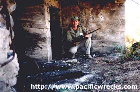
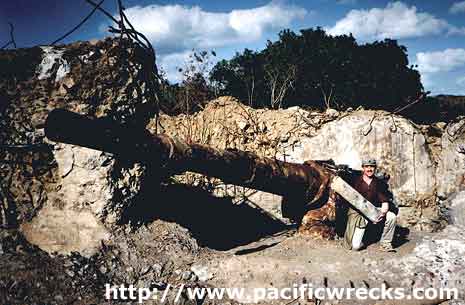
One of the more interesting sites we encountered
was a Japanese coastal gun battery that we happened upon, inland
from Iwo's west coast. As we walked up a road we came upon an extensive
cave complex, then a large blockhouse, then the coastal gun itself.
Discovering a cave entrance beneath the blockhouse,
one of our group decided to enter the cavern with his searchlight.
However, with the inside registering a blistering 130 degrees, he
returned within a minute, amazed at how anyone could have labored
in these conditions to build the tunnel complex.
Cave Near Hill 362A
Mouth of large cave in 5th Division's zone
of action, near Hill 362A. The high temperatures (120+ degrees)
and volcanic steam vents inside prevent the taking of most pictures
or video footage because the lenses immediately fog up!
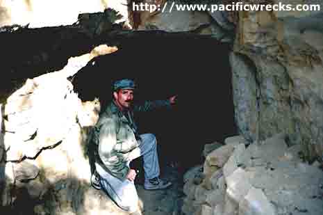
Japanese Hospital Cave
Flagging down another Marine truck on his circuit,
we hopped in and soon found ourselves at another cave complex, this
one having been used by the Japanese as a hospital. This photograph
shows the view of interior of hospital cave in northwestern section
of Iwo. Navigation lights have been installed by marines to help
guide visitors. It was here in 1984 that the mummified remains of
several Japanese soldiers were found, complete with weapons and
uniforms.
Although my travel companions and I were making
good time on the ground and exploring as many former fortifications
as possible, we knew we had to catch a truck for a ride up to Mt. Suribachi
before it got too late in the day. Flagging down a truck, we soon found
ourselves in long line of trucks who were backed up at the foot of Suribachi;
the traffic jam apparently due to the Japanese, who were holding their own ceremony on Suribachi at that
moment, which was off-limits to the American visitors. So, with time
passing quickly, my friends and I soon exited the truck to explore more
of the southern and western sections of Iwo.
Before we knew it, dusk was fast approaching and we
boarded another truck to take us up to Suribachi before sunset. However,
much to our disappointment, many of us never made it because no more
trucks were allowed up the mountain due to the need to round everyone
up for the flight back to Saipan and Guam. So, on the one hand I'm a
bit disappointed at not standing atop Suribachi, on the other, I'm pleased
at all the ground I covered and the caves and fortifications I discovered
and photographed.
Airfields on Iwo Jima
Before the battle for Iwo, the Japanese had two
fully operational airfields and were in the process of constructing
a third when the Americans landed. At the conclusion of the battle,
only the two operational airfield were used: Motoyoma No. 2 being lengthened to support the B-29s. Eventually, Motoyama No.1 was abandoned with only the main airfield being used today. The real estate for the third being used for aircraft revetments
and other installations. The occupation forces called them either
Motoyama 1 and 2, or Airfields and 2. It's amazing to see aerial
photos taken of Iwo later in 1945 after the Seabees had covered
it with road networks, asphalt and Quonset huts (a lot of stuff
in a very small space).
Veterans
Late in the day, as our truck was driving along,
on its way back to the airfield, I remarked that we were probably in
the area that had been the scene of intense fighting involving the 3rd
Battalion, 23rd Regiment, 4th Marine Division. One of my companions
on the truck asked me if I knew who the CO of the 3rd Bn was during
the battle. After a quick glance at my Iwo reference book, I replied,
"Major James F. Scales", to which my companion then said,
"Did you know you're sitting next to him?" Indeed, the man
sitting next to me with the sly grin was none other than Jim Scales
himself. Talk about a coincidence!
Excerpt from the book, Iwo
Jima: Legacy of Valor
"Hill 382 was the defiant obstacle to the Fourth
Division advance, but General Cates was determined to have it by
nightfall. Its defenders were just as determined to hold out as
long as they could and to kill Marines until the last man fell. Major Jim Scales Third Battalion of the 23rd Regiment
was the first to move out, this time with Lieutenant Colonel Louis
B. Blissard's First Battalion. It was immediately obvious that the
Meat Grinder had lost none of its ferocity. Both 382 and Turkey
Knob came violently alive with the first sign of the Marine attack.
Time and again Scales' battalion smashed against
the side of the hill, only to be rolled back like spent surf. There,
in the ruins of the crumpled radar tower and the rubble of its building,
they held out for two hours in hand-to-hand combat against counterattacks;
wave after wave of superior numbers of Japanese were beaten off
until Marines exhausted their ammunition and had to fall back down
the hill.
Diving Underwater wrecks
There are no underwater wrecks, although it does
bear mentioning that the actual shape of Iwo Jima has changed somewhat
over the past 50+ years because of some concrete block ships that the
US Navy sank off Iwo's west coast in September 1945. Due to the action
of storms and tides these block ships caused a peninsula to form, joining
the small islet of Kama Rock to the main island.
|