|
|
|
|
| Missing In Action (MIA) | Prisoners Of War (POW) | Unexploded Ordnance (UXO) |
| Chronology | Locations | Aircraft | Ships | Submit Info | How You Can Help | Donate |
|
   7th AF c1945  USMC Feb 19, 1945 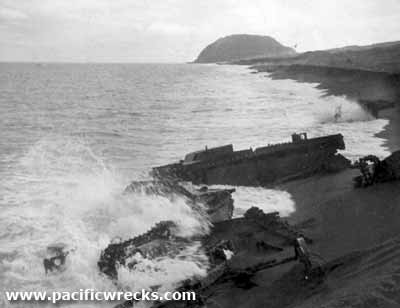 Don MacArthur 1952 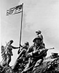 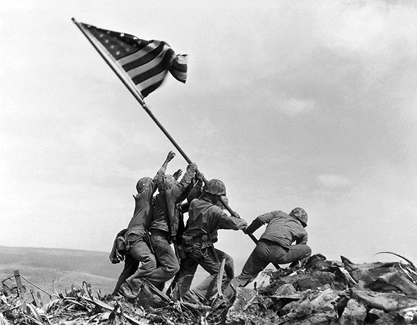 Rosenthal Feb 23, 1945 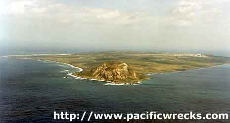 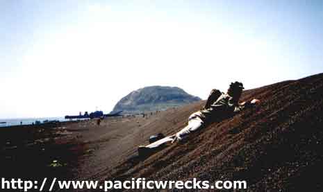 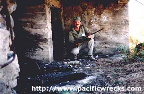 Sean Prizeman 1995 |
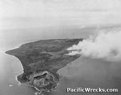
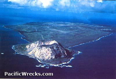
Location Lat 24°47′N Long 141°19′E Iwo Jima 硫黄島 is part of the Volcano Islands in Ogasawara Subprefecture in Japan. In Japanese, Iwo To or Iwo Jima means "Sulfur Island". Surrounded by the North Pacific Ocean, the island is less than five miles long and two and a half miles wide at its widest point and has been described by many as pork chop shape when viewed from the air and has no source of potable water. Located 80 km to the north is North Iwo Jima (Kita Iwo Jima). Iwo Jima is located south and west of the midpoint between Tokyo on Honshu in Japan and Saipan in the Mariana Islands. In Japanese, Iwo To or Iwo Jima means "Sulfur Island". Prewar and in Japan the correct name for the island was Iwo To. During World War II, the Americans referred to the island as Iwo Jima. Postwar, many Japanese referred to as Iwo Jima by the Japanese. Wartime History Prewar and during the early Pacific War, Iwo Jima was part of the ferry route for aircraft flying southwards. After the Pacific War turned against the Japanese efforts were made to fortify the island against an anticipated U.S. assault. During June 1944, Japanese Army Lieutenant General Tadamichi Kuribayashi took command of the garrison and began planning the defense of the island with a strong defense in depth supported by tunnels and defenses and heavy weapons sighted on the likely landing beaches. The Japanese force was comprised of roughly 22,000 personnel that worked to prepare defenses, dig tunnels and sight heavy weapons including machine guns, artillery, mortars and rockets. Also defending was the 26th Tank Regiment under the command of Lt. Col. Takeichi Nishi with Type 97 and Type 95 tanks that he ordered to be dug in as stationary armored pillboxes in three locations. On July 4, 1944 Iwo Jima was first targeted by U.S. Navy (USN) carrier aircraft to sweep the island and a naval bombardment to destroy defenses. Despites the initial attacks, Iwo Jima's radar provided an early warning system and interception base for Japanese fighters to attack B-29 Superfortresses as they passed the island. The American bombing campaign was aided by heavy bombers from the Marianas that continued to pound the island to neutralize defenses ahead of the Marine landing and afterwards to provide close air support. American missions against Iwo Jima July 4, 1944–February 27, 1945 On February 19, 1945 the U.S. Marine Corps (USMC) made an amphibious landing on the invasion beaches on the southern coast near Mount Suribachi and faced heavy fire from Japanese Army soldiers defending from tunnels, bunkers and concealed positions. The first day of combat resulted in 2,400 American casualties. While the battle was still raging, Iwo Jima airfields were quickly repaired and expanded to allow American bombers and fighters to make emergency landings until the end of the Pacific War. On March 25, 1945 the island was deemed secured and the Battle of Iwo Jima was officially ended. In total, the Japanese lost roughly 20,000 with over 1,000 taken prisoner. Mopping up contuned for months. Some Marines remain to assist in mop-up activities. On April 12, 1945 the last unit of the 9th Marines, 3d Marine Division depart on April 12, 1945. Iwo Jima garrison duty became the responsibility of the U.S. Army, 147th Infantry Regiment Postwar During the U.S. occupation of Japan, American forces maintained a presence on Iwo Jima until the end of the Korean War. In 1968, Iwo Jima was returned to Japan and was the last part of Japan under U.S. military control but continued to maintain a small American presence in the form of a U.S. Coast Guard (USCG) station until closed in October 1993. Today Since 1968, the Japanese Self Defense Force (JSDF) maintains a base on Iwo Jima including Iwo Jima Airport (Motoyama No. 2, Airfield No. 2, Central Field). Today, Iwo Jima is off limits to outside visitors or tourists, aside for the annual World War II memorial services held once a year. Invasion Beach Located on the east coast of the island. Site of the massive American landing on Iwo Jima. The amphibious assault on Iwo Jima was considered to be the "ultimate storm landing," with a striking force of 74,000 Marines. The U.S. Marine 4th and 5th Divisions led the invasion, with the 3rd Division in reserve. After the war, the landing beaches were largely cleared of wreck age which was sold as scrap metal. Mount Suribachi (Suribachiyama) Volcanic cone with a 550' summit at the southwest tip of Iwo Jima. During the Pacific War, the Japanese dug tunnels, caves and fighting positions with a seven-story interior structure. Heavily bombed and napalmed by American aircraft during the assault. The summit was captured on February 23, 1945, sight of the first and second flag raising and memorial. Japanese Bunkers and Tunnels Prior to the American assault, the Japanese built 16 miles of tunnels into Iwo Jima for defenses and living quarters and a hospital 46' underground. Many of these tunnels were tombs for Japanese defenders killed on the island. In 1984, three mummified Japanese soldiers were discovered in a cave. General Kuribayashi Bunker (General's Bunker) Located near the northern end of Iwo Jima. A large tunnel complex that reaches 75' underground with five levels. Sgt G. W. Rosson recalls from 1946: "We went all through the General's cave down to the 2nd level. All of the halls 4' by 6' would go down at a 60 degree to the next level. The General's cave is 75 feet deep at the bottom floor. Lot of stories of what was in that cave, one small room had a bath tub half way in the ground. One room had chairs and tables all over the place. There were a lot of Japanese paper all over the floor. We went down to the next level it got hotter and the smell was bad. We came to the next opening going down to the next level. Since this was the General's cave we new that there had to be another way out. We found it a big wooden door that we couldn't get open. In one of the rooms there were 8 or 9 dead bodies. The smell was bad, their skin was dried up. There were a lot of air shafts going up." Motoyama No. 1 (Airfield No. 1 Chidori, South Field) Japanese built airfield on the southern corner of the island Motoyama No. 2 (Airfield No. 2, Central Field, Iwo Jima Airport) Japanese built airfield in the center of the island, expanded by the Americans and still in use today Motoyama No. 3 (Airfield No. 3, North Field) Japanese airfield never completed converted into aircraft revetments and installations F6F Hellcat Bureau Number 43041 Pilot Nisi MIA July 4, 1944 off Iwo Jima USS Bismarck Sea CVE-95 Sunk February 21, 1945 by kamikaze aircraft off Iwo Jima Type 97 Chi-Ha Shinhoto Medium Tank Captured on Iwo Jima, taken to the United States for evaluation References The History of Battles of Imperial Japanese Tanks Part II Marines in World War II Historical Monograph Iwo Jima: Amphibious Epic Naval History and Heritage Command (NHHC) Battle of Iwo Jima: A Select Bibliography Naval History and Heritage Command (NHHC) Battle for Iwo Jima, 1945 Naval History and Heritage Command (NHHC) Battle for Iwo Jima 19 February–26 March 1945 The Washington Post "There were two flags raised at Iwo Jima. The Marines now say they misidentified men at both." August 24, 2016 Contribute
Information Last Updated
|
Map 1945 Map Fallingrain Photo Archive View in Earth |
| Discussion Forum | Daily Updates | Reviews | Museums | Interviews & Oral Histories |
|