|
|
|
|
| Missing In Action (MIA) | Prisoners Of War (POW) | Unexploded Ordnance (UXO) |
| Chronology | Locations | Aircraft | Ships | Submit Info | How You Can Help | Donate |
|
 Tom Burchill1999 |
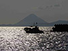
Location Kagoshima Bay (Kagoshima Wan) 鹿児島湾 borders Kagoshima Prefecture on Kyūshū in Japan. Also spelled Kagosima Bay. At the center is Mount Sakurajima (Mt. Sakurajima) and on the southern entrance is Mount Kaimondake. Borders Kagoshima (Kagosima) to the west and the Ōsumi Peninsula to the east. At the southern tip is Cape Sata (Sata Misaki) and beyond the East China Sea. Mount Sakurajima (Mt. Sakurajima) Mount Sakurajima (Mt. Sakurajima) is an active volcano at at roughly the center of Kagoshima Bay. Mount Kaimondake (Mt. Kaimon) Mount Kaimondake (Mt. Kaimondake) is located near Ibusuki at the southern end of Kagoshima Bay. During 1945 during the Okinawa campaign, Japanese kamikaze pilots would circle Mount Kaimondake as a farewell to Japan before flying south to attack U.S. warships off Okinawa. Wartime History Starting in April 1945 attacked by U.S. aircraft until the end of the Pacific War. American missions against Kagoshima Bay April 21, 1945–August 6, 1945 Contribute
Information Last Updated
|
Map March 29, 1945 Map April 16, 1945 Map Fallingrain |
| Discussion Forum | Daily Updates | Reviews | Museums | Interviews & Oral Histories |
|