|
|
|
|
| Missing In Action (MIA) | Prisoners Of War (POW) | Unexploded Ordnance (UXO) |
| Chronology | Locations | Aircraft | Ships | Submit Info | How You Can Help | Donate |
|
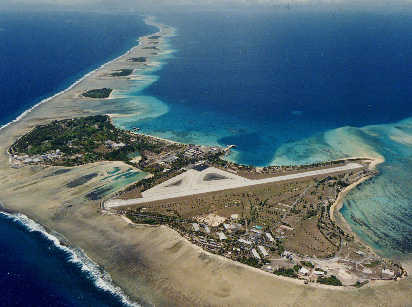 USN c1990s 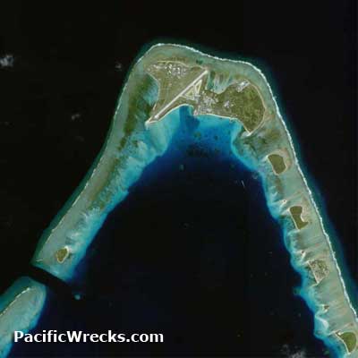 Google Earth 2002 |
Location Lat 9° 23' 49N Long 167° 28' 15E Roi-Namur Island is located in the Northern Atoll in Kwajalein Atoll in the Marshall Islands. Prewar and during the Pacific War until December 1944, Roi-Namur Island were two separate islands: Roi Island to the west and Namur Island to the east. They were connected by a narrow neck of land and a causeway. During late 1944 during the U.S. occupation, fill was added between Roi Island and Namur Island, forming Roi-Namur Island, also known as simply Roi-Namur. Prewar In 1914, during World War I, Japan occupied the Marshall Islands and developed Roi Island and Namur Island and built Roi Airfield. Wartime History On December 8, 1941 at the start of the Pacific War, Japanese bombers from Roi Airfield bomb Wake Island. Starting in late 1943 targeted by American aircraft ahead of Operation Flintlock to capture Kwajalein Atoll. American missions against Roi-Namur December 21, 1943–February 1, 1944 American Occupation On February 2, 1944 during "Operation Flintlock" American forces landed at Roi and Namur and secured the islands in only eight hours. Lt. Col Aquilla James Dyess earned the Medal of Honor posthumously, leading his troops in an advance. After the American occupation, U.S. Navy (USN) Naval Construction Battalion (NCB) "Seabees" filled in the area between Roi Island and Namur Island, forming Roi-Namur by December 1944. Roi-Namur Airfield (Roi Airfield, Dyess AAF) Built by the Japanese, captured by American forces in February 1944. Still in use today. Japanese Installations Many of the Japanese installations have been left standing and are preserved for residents and visitors. Several large cement blockhouses used for munitions and fuel storage. Air headquarters building is testament to the furious battle. Its cement roof shows evidence of bomb and projectile damage from guns of many sizes. Many pillboxes are around the island and several bomb shelters. Japanese hospital Near the modern ALCOR Radar station is the remains of a Japanese hospital, with a corrugated tin roof. It is completely overgrown. Inside are remains of examination tables, gas canisters and sheets of X-ray film. Shallows near the reef All the war related wreckage was bulldozed onto the reef. Often rusted remains are washed ashore. It is not difficult to find coins, dog tags, bottles, knives and ammunition washed onto shore. Of the many Japanese planes destroyed on the ground during US air strikes, little remains, except for some debris that have been heaped into the shallows. The only recognizable portion is the wing section of a Val in about 3 feet of water off the end of the runway. Off near the runway are the corroded remains of a landing craft in the shallows of the reef. Japanese Twin 127mm Anti-Aircraft Gun Type 89 (1929) Emplaced in a parapet near North Pass West Reef F4U Corsair Crash on the reef B-25 Mitchell Ditched or dumped into the sea off Roi Namur Aircraft Dump Area A large group of aircraft were dumped between North Pass and Mellu Island. The aircraft rest on a sandy bottom at a depth of 30' to 130'. The aircraft include over a dozen F4F Wildcat fighters, SBD Dauntless dive bombers and other types of aircraft. All the aircraft were partially stripped of parts before they were dumped by American forces. These aircraft have no external damage and were likely dumped as surplus or war weary. Today, the aircraft form an artificial reef for coral and fish life. F4F Wildcat (Fuselage No. 1) Dumped during the war or postwar F4F Wildcat (Fuselage No. 2) Dumped during the war or postwar Contribute
Information Last Updated
|
December 22, 1943 Map Fallingrain |
| Discussion Forum | Daily Updates | Reviews | Museums | Interviews & Oral Histories |
|