 |
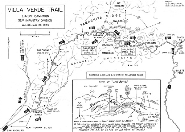
Map of Villa Verde Trail Luzon Campaign 32nd Infantry Division January 30–May 28, 1945
Indicated is the Villa Verde Trail in the foothills of the Caraballo Mountains in central Luzon in the Philippines with San Nicolas, Santa Maria, The Bowl, S Pass No. 2, S. Pass No. 1, Yamashita Ridge, Mt. Imugan, Imugan and Santa Fe. On the right edge is Highway 5 and Balete Pass. The black arrows indicate the advance of the 126th Infantry Regiment, 127th Infantry Regiment and 128th Infantry Regiment. Letters indicate terrain features: sketch A, sketch B, sketch C and sketch D. At the lower center inset Sketch B: End of "The Bowl". Map compiled by Captain J.E. Ash, F.A. 2nd Battalion, 127th Infantry Regiment.
Credit: U.S. Army, 32nd ID, 127th IR Date: January 30, 1945–May 28, 1945
Map
High Resolution Version
Acquire This Image |
Contribute Information
Do you have photos or additional information?
Previous Page
|
|