|  |
|
| |
|
| Missing In Action (MIA) | Prisoners Of War (POW) | Unexploded Ordnance (UXO) |
| Chronology | Locations | Aircraft | Ships | Submit Info | How You Can Help | Donate |
|
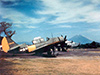 USAAF April 1945 |
Location Lat 13°15′24″N 123°41′06″E Mount Mayon (Mayon Volcano) is an active stratovolcano with a symmetric conical shape with the peak at an elevation of 8,081' / 2,453m in Albay Province in the Bicol Region (Region V) of Luzon in the Philippines. Also known as simply Mayon. Mayon is the most active volcano in the Philippines, erupting over 52 times in the past 500 years. To the southwest is Camalig and beyond to the southeast is Legaspi (Legazpi). During 1616 an eruption was first documented during the Spanish colonial era. On July 20, 1766 was another major eruption with lava flows. On January 31, 1814 a series of minor earthquakes were felt in the area. On February 1, 1814 at 8:00am Mayon had a plinian eruption that destroyed Cagsawa with roughly 1,200 killed what is considered to be the most lethal eruption with 9m of ash. Starting on July 6, 1881 until roughly August 1882, Mayon underwent a strong eruption with lava flows halfway down the slope. On July 20, 1938 became the first Philippines national park. During 2000, It reclassified as a natural park and renamed the Mayon Volcano Natural Park. In 2016 became a UNESCO Biosphere Reserve and was nominated as a World Heritage Site. On January 1, 2026, Mayon Volcano was placed under Alert Level 2 by the Philippine Institute of Volcanology and Seismology (PHIVOLCS). Contribute Information Do you have photos or additional information to add? Last Updated October 10, 2026 |
 Map Mapcarta |
| Discussion Forum | Daily Updates | Reviews | Museums | Interviews & Oral Histories |
|