|
|
|
|
| Missing In Action (MIA) | Prisoners Of War (POW) | Unexploded Ordnance (UXO) |
| Chronology | Locations | Aircraft | Ships | Submit Info | How You Can Help | Donate |
|
 Justin Taylan 2003 |
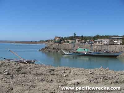
Location Lat 17° 46' 60N Long 120° 25' 0E Salomague is located at an elevation of 3' above sea level on the western coast of Luzon in Ilocos Sur Province in Region I (Ilocos Region) of the Philippines. Also spelled Salomague or Salamague. At the coast is the Port of Salomague. To the south is Vigan. Wartime History On December 10, 1941 Japanese Army landed at Salomague unloading trucks and troops that moved southward to occupy Vigan. During the Japanese occupation of the Philippines, used by the Japanese as a port area. Starting in January 1945 attacked by American fighters and bombers. American missions against Salomague January 17-19, 1945 Port of Salomague Site of the landings by the Japanese on December 10, 1941, unloading trucks and troops to occupy the province's main town of Vigan. Today, it is a small port used by local fisherman only, with the port at Currimao used for commercial shipping. P-47D Thunderbolt 42-23208 Pilot Cain crashed January 17, 1945 bailed out at 1,000' to hit the floating plane when he landed Contribute
Information Last Updated
|
Map Fallingrain |
| Discussion Forum | Daily Updates | Reviews | Museums | Interviews & Oral Histories |
|