|
|
|
|
| Missing In Action (MIA) | Prisoners Of War (POW) | Unexploded Ordnance (UXO) |
| Chronology | Locations | Aircraft | Ships | Submit Info | How You Can Help | Donate |
|
  5th CCU January 5, 1943 |
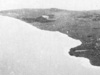
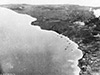
Location Cape Gazelle is located at the northeast tip of the Gazelle Peninsula on New Britain. Borders Saint Georges Channel to the east and Duke of York Islands to the northeast. Inland to the west is Tokua. Between 1884 until September 1914 part of Deutsch Neu Guinea (German New Guinea). Prewar and during the Pacific War part of the New Britain District in the Territory of New Guinea. Today located in East New Britain Province of Papua New Guinea (PNG). Wartime History During late January 1942, occupied by the Japanese. At this location, a shore battery was established to defend Saint Georges Channel to the east and the entrance to Blanche Bay to the north and west. Starting in June 1943 until the end of the Pacfic War targeted by Allied aircraft. Cape Gazelle was occupied by the Japanese until September 1945 when Japan officially surrendered. American missions against Cape Gazelle June 11, 1943–June 16, 1944 Contribute
Information Last Updated
|
Map 1912 |
| Discussion Forum | Daily Updates | Reviews | Museums | Interviews & Oral Histories |
|