|
|
|
|
| Missing In Action (MIA) | Prisoners Of War (POW) | Unexploded Ordnance (UXO) |
| Chronology | Locations | Aircraft | Ships | Submit Info | How You Can Help | Donate |
|
 AWM 1914 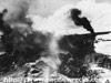 5th AF Feb 15, 1944 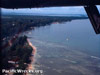 David Paulley 1982 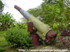   Claude Gibson 2001  Harumi Sakaguchi 2003 |
Location Lat 2° 34' 0S Long 150° 48' 0E Kavieng is located on North Cape on the northwest of New Ireland. Borders to the west Kavieng Harbor, Nusa Harbor, Nusa Island and Nusalik Island. To the north is Cape Nuan and beyond North Cape. Also known as "Kavieng Town", "Kawieng" or "Kaewieng". Prewar and during the Pacific War located in the Territory of New Guinea. Today, Kavieng is the provincial capital of New Ireland Province. Today located in Kavieng Urban LLG in Kavieng District in New Ireland Province in Papua New Guinea (PNG). Prewar Kavieng was settled by the Germans who built a government station, developed Kavieng Harbor and constructed a network of roads and copra plantations on New Ireland. World War I During 1914, Kavieng was occupied without opposition by the Australian Naval and Military Expeditionary Force (AN&MEF). Afterwards administered by Australia as part of the Territory of New Guinea. World War II During July 1941, a small Australian Army Imperial Force from No. 3 Section plus 250 commandos of the 1st Independent Company arrived at Kavieng and began construction of Kavieng Airfield. On December 25, 1941, as the threat of the Pacific War became imminent, white women and children were evacuated by the administration. On January 21, 1942 over sixty Japanese carrier aircraft attacked Kavieng without opposition. During the night of January 21-22 most Australians were evacuated from Kavieng by 10:30pm. A few opted to stay behind to destroy installations then planned to escape aboard two small ships Navanor and Shamrock. During the night of January 23, 1942 until the morning of January 24, 1942 a Japanese force from Truk lands at Kavieng and found virtually no opposition. Afterwards, the No. 2 Maizuru Special Naval Landing Force (2nd Maizuru SNLF) were transported to New Hanover, Mussau and Emirau looking for Allied soldiers but found no opposition and by late January 1942 returned to Rabaul. Japanese missions against Kavieng January 21, 1942–April 8, 1944 During late January 1942 Kavieng was developed by the Imperial Japanese Navy (IJN) into a base area, anchorage in Kavieng Harbor and shore facilities for Kavieng Seaplane Base was used by seaplanes. Many Japanese veterans recalled the area as "that it is a beautiful place as the heaven". The kanji for Kavieng "Ka-bi-en" translates to "excellent-beautiful-garden". By August 1942, Allied aircraft began bombing Kavieng, culminating in heavy aerial attacks in early 1944 that neutralized the area with bombing and low level strafing and left the area cut off from resupply by ships or aircraft. Due to the heavy attacks in early 1944, the Japanese believed the Allies might conduct an amphibious landing at Kavieng. In response, Japanese Navy Rear Admiral Ryukichi Tamura the commander at Kavieng ordered all Allied prisoners killed due to the expected invasion. At least 25 Australian civilians were executed at Kavieng Wharf (Main Wharf). American missions against Kavieng August 17, 1942–April 8, 1944 Allied plans originally called for an Allied amphibious invasion of Kavieng. On March 12, 1944 the Joint Chiefs canceled the invasion, in favor of landings at Hollandia and Emirau. Although bypassed, Japanese forces occupied Kavieng for the remainder of the Pacific War until the official surrender of Japan in early September 1945. Today Postwar, Kavieng was rebuilt, but many wartime reminders remain including bomb craters, bunkers, pillboxes, Naval guns and fortifications from the war. Don Fetterly adds: "There are still bomb craters in Kavieng township itself and one can look and imagine the B-25 staffers coming along the sea front and pounding away at anything that moves. I have with me some very good war time maps of Kavieng and these will help me to trace the gun pits and taxi ways along the airfield." Kavieng Airfield Built by the Australians prior to the war, occupied by the Japanese until the end of the war. B-25D "Jack Rabbit Express" 41-29992 Pilot Hecox crashed February 15, 1944 Chinatown The Chinatown area is located at the northern end of Kavieng, to the northwest of Kavieng Airfield. Established prewar as the Chinese living quarter for Kavieng. B-25G Mitchell 42-64873 Pilot Difilippo crashed February 15, 1944, 5 missing References The Japanese Invasion of New Ireland by Jim Ridges Contribute
Information Last Updated
|
Map 1944 Map Fallingrain Photo Archive |
| Discussion Forum | Daily Updates | Reviews | Museums | Interviews & Oral Histories |
|