|
|
|
|
| Missing In Action (MIA) | Prisoners Of War (POW) | Unexploded Ordnance (UXO) |
| Chronology | Locations | Aircraft | Ships | Submit Info | How You Can Help | Donate |
|
 USAAF June 1943  Justin Taylan 2000  Justin Taylan 2006 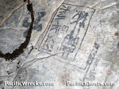 Justin Taylan 2006 |
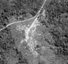
Location Lat 4° 17' 60S Long 152° 7' 60E Malmaluan is located on a ridge in the Gazelle Peninsula in New Britain overlooking Karavia Bay and further to the northeast is Rabaul. Pronounced "marl-maa-lou-an". Wartime History Occupied by the Japanese January 1942 until September 1945. During the war, extensive concrete bunkers, underground fornications and anti-aircraft and naval guns were emplaced in this area. Coastwatcher's Memorial Lookout (Coastwatcher's Memorial) Located off the Vuruga Road (Burma Road). Also know as Coastwatcher's Lookout or Coastwatcher's Memorial and Coastwatchers Reserve. Crescent Shaped Bunker This concrete bunker, located parallel to the road has a sloping downward, crescent shaped roof. There are two entrances, one on each end, with stairs leading downward into a straight tunnel, with a 'T' at the center, leading downward (sealed). Remains of metal doors are present at each entrance. A circular armor emplacement is located at the western side, with a pivot point and track at the base (machine gun or range finder?). A similar fortification is off the eastern side. In the village behind the bunker, Type 41 Gun Control Radar Located just behind the crescent shaped bunker, the circular base, and 'U' shaped upper arms only. The screen portion is missing. Tunnel Tunnel with two entrances and stairs leading downward into four rectangular shaped tunnel rooms. The inside is empty, ventilation holes connect to the outside through chimneys. Some kanji remains on the ceiling of the tunnel, indicating it was made with Portland Cement (manufactured from limestone and clay and that hardens under water). The origin is 1810, named after the Isle of Portland in Dorset, England, a limestone peninsula quarried for fine building stone. Contribute
Information Last Updated
|
Map Fallingrain |
| Discussion Forum | Daily Updates | Reviews | Museums | Interviews & Oral Histories |
|