|
|
|
|
| Missing In Action (MIA) | Prisoners Of War (POW) | Unexploded Ordnance (UXO) |
| Chronology | Locations | Aircraft | Ships | Submit Info | How You Can Help | Donate |
|
 Justin Taylan May 15, 2024 |
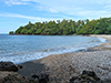
Location Lat 5° 29′ 38″ S Long 145° 55′ 17″ E Marakum is located at an elevation of 33' / 10m on the Rai Coast area of the north coast of New Guinea. To the west is the Guabe River. To the east is Bau Plantation. Prewar and during the Pacific War located in the Madang District of the Territory of New Guinea. Today, located in Rai Coast District of Madang Province in Papua New Guinea (PNG). Wartime History During late December 1942 or early 1943 the area was occupied by the Imperial Japanese Army (IJA). During 1943–1944 used by the Japanese as a barge hideout and supply dump area. By March 28, 1944 the U.S. Army, 126th Infantry Regiment (126th IR) advanced to this location and was reported clear of any Japanese defenders. At Marakum. they found evidence of the area used as a barge hideout with eleven sunken barges, six engineer assault boats (collapsible boats) and quantities rifles, ammunition, grenades and supplies. Japanese Barge Wreckage Underwater Wreckage of a barge in shallow water. Japanese Barge Wreckage Beach Wreckage of barge on the beach. References HQ First Aust Army Weekly Intelligence Summary No. 100 Compiled from information received from 1200 hrs 28 Mar 44 to 1200 hrs 4 Apr 44, page 4 (AWM: AWM52 1/3/5/25 - April 1944 PDF page 20) "Yalau: The Kambara and Guabe River area and what appeared to have been a former barge hide-out was reported clear of enemy on 28 Mar [1944]. Quantities of abandoned enemy equipment including blankets, rifles, hand grenades and ammunition were found in the vicinity of Marakum together with 11 sunken barges, six engineer assault boats and quantities of wire and rope." Contribute
Information Last Updated
|
Map Fallingrain Map Mapcarta |
| Discussion Forum | Daily Updates | Reviews | Museums | Interviews & Oral Histories |
|