Missing In Action (MIA)
Prisoners Of War (POW)
Unexploded Ordnance (UXO)
Chronology
Locations
Aircraft
Ships
Submit Info
How You Can Help
Donate
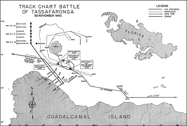
Map of the
Battle of Tassafaronga
Solid black line indicates the track of Imperial Japanese Navy destroyers:
Naganami
,
Takanami
sunk by gunfire off
Tassafaronga
,
Kuroshio
, Oyashio, Kagerō, Suzukaze,
Kawakaze
, and
Makinami
.
Solid black line indicates the track of U.S. Navy cruisers. At 22:22 both
USS Minneapolis (CA-36)
and
USS New Orleans (CA-32)
sustained torpedo hits and withdrew. At 23:39
USS Pensacola (CA-24)
was also hit by a torpedo and withdrew and the track of
USS Honolulu (CL-48)
. Also indicated is
Iron Bottom Sound
between
Florida Island
,
Savo Island
and the north coast of
Guadalcanal
.
Credit: USN Date:
November 30, 1942
Map
High Resolution Version
Acquire This Image
|
Contribute Information
Do you have photos or additional information?
Previous Page
Discussion Forum
Daily Updates
Reviews
Museums
Interviews & Oral Histories
Pacific Wrecks Inc.
All rights reserved.