 |
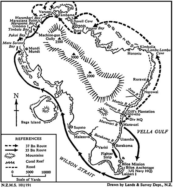
Map of New Zealand Army offensive during the Land Battle of Vella Lavella (Vella Lavella Campaign) on Vella Lavella Island
Locations on Vella Lavella include from the south, clockwise: Biloa Mission, Biloa Anchorage, Fighter Strip (Barakoma Airfield), Barakoma, Barakoma River, Uzamba, Maravari, Maravari River, Gill's Plantation / Joroveto / Divisional HQ, Jaroveto River, Mumia River, Juno River, Narowai, Ruravai, Lambu Lambu Cove, Kimbolia, Horoniu, Paraso Bay, Doveli Cove, Boro, Tambama, Varuasi, Machine gun Gully (elevation 2,500'), Warambari Bay, Maraziana Point, Marquana Bay, Umomo Isalnd, Timbala Bay, Pakoi Bay, Motu Soroto Bay, Mundi Mundi, Supato, Malasova, Varisi. Offshore islands: Baga Island (Mbava), Turovilu Island Laipari Island and Ozama Island. Offshore water bodies include: Vella Gulf and Wilson Strait. The solid arrow is the route of the New Zealand Army, 3rd
New Division, 35th Battalion. The dotted arrow is the route of the New Zealand Army, 3rd
New Division, 37th Battalion.
Credit: New Zealand Lands & Survey Department Date: September 1943
B&W
High Resolution Version
Acquire This Image |
Contribute Information
Do you have photos or additional information?
Previous Page
|
|