|
|
|
| Missing In Action (MIA) | Prisoners Of War (POW) | Unexploded Ordnance (UXO) |
| Chronology | Locations | Aircraft | Ships | Submit Info | How You Can Help | Donate |
|
 USAAF January 5, 1943  5th AF November 1943 |
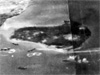
Location Matupi Harbor is located off the southern tip of the Gazelle Peninsula of New Britain in East New Britain Province in Papua New Guinea. To the north is Mother, east is Tavurvur (Matupi Volcano), to the west is Matupi Island (Matupit), to the south is Blanche Bay. Further to the northwest is Lakunai Airfield and beyond is Rabaul. Also known as Matupit Harbor. Wartime History During the Japanese occupation of the area, Matupi Harbor was used by small vessels and barges as an anchorage on a limited basis. The Japanese established several gun batteries that could fire southward to defend Blanche Bay. Allied mission against Matupi Harbor January 23, 1944–October 15, 1944 Contribute
Information Last Updated
|
Photo Archive Map March 18, 1943 |
| Discussion Forum | Daily Updates | Reviews | Museums | Interviews & Oral Histories |
|