|
|
|
|
| Missing In Action (MIA) | Prisoners Of War (POW) | Unexploded Ordnance (UXO) |
| Chronology | Locations | Aircraft | Ships | Submit Info | How You Can Help | Donate |
|
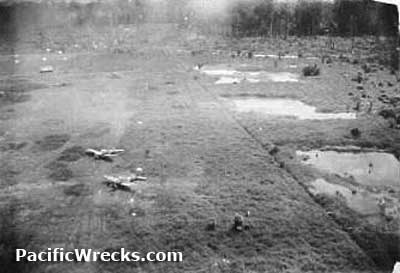 USAAF 1944 |
Location Lat 1° 11' 7N Long 127° 53' 46E Kaoe Airfield is located at an elevation of 27' above sea level to the north of Kaoe (Kao, Kau) on the eastern coast of the northwestern arm of Halmahera Island in the Molucca Island Group (Molucca Islands). Also known as Kao or Kau. Allied wartime spelling "Kaoe". Prewar and during the Pacific War located in the Netherlands East Indies (NEI). Today located in North Maluku Province (Provinsi Maluku Utara) in Indonesia. Construction Kaoe Airfield had two runways known as Kanoe I and Kaoe II. Wartime History Used by the Japanese as a military airfield. During the middle of 1944 until early December 1944 attacked by American aircraft. American missions against Kaoe August 21, 1944–December 7, 1944 Today Still in use today as Kao Airport. Airport codes: ICAO: WAMK and IATA: KAZ. It is unclear if this is the wartime runway or a new construction, but the present day runway is in the same general location as Kaoe II. Contribute
Information Last Updated
|
Map Fallingrain |
| Discussion Forum | Daily Updates | Reviews | Museums | Interviews & Oral Histories |
|