|
|
|
|
| Missing In Action (MIA) | Prisoners Of War (POW) | Unexploded Ordnance (UXO) |
| Chronology | Locations | Aircraft | Ships | Submit Info | How You Can Help | Donate |
|
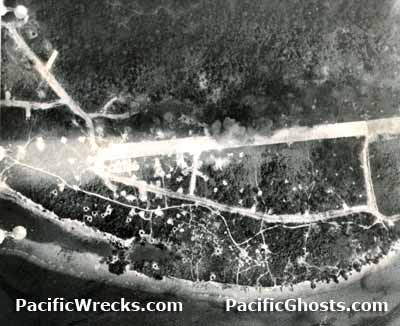 5th AF c1944 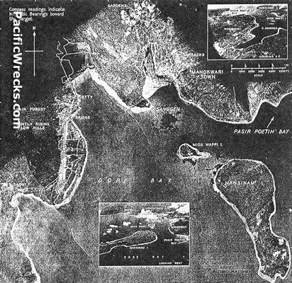 USAAF May 15, 1944 |
Location Lat 0° 53' 30S Long 134° 2' 57E Manokwari Airfield is located to the southwest of Manokwari on the eastern end of the Vogelkop Peninsula. Borders Dore Bay to the east and off shore is Weppi Island and Mansinairo Island. Today located in the Manokwari Regency of West Papua Province in Indonesia. Construction Built by the Japanese as a single runway parallel to the coast with taxiways and revetments. Wartime History Used by the Japanese as a military airfield. Between May 1943 until late October 1944 attacked by Allied bombers and fighters. American missions against Manokwari May 1, 1943–October 24, 1944 Today Still in use today as Manokwari Airport or Rendani Airport. Airport codes: ICAO: WASR, IATA: MKW. The single runway is oriented 35/17 and measures 6,576' x 95' surfaced with asphalt. Bruce Fenstermaker adds: "There are buried jeeps, trucks etc there. I spent about 3-4 days there [in mid-1990s]. If I remember when Elliott Smock went there he was not permitted to go any further than the harbor dock because of problems. There are landing craft 3+ miles to the north west on the beach also." Contribute
Information Last Updated
|
Map May 15, 1944 Map Fallingrain View in Google Earth Photo Archive |
| Discussion Forum | Daily Updates | Reviews | Museums | Interviews & Oral Histories |
|