|
Location
Lat 1° 33' 0" Long 134° 11' 0" Ransiki Airfield is located at an elevation of 52' above sea level to the north of Ransiki (Ranasiki) and the Ransiki River on the Vogelkop Peninsula in western New Guinea. Also known as "Ransiki Drome" or "Moemi North". To the south is Moemi (Momi) and beyond Waren (Wareng). Prewar and during the Pacific War located in Dutch New Guinea (DNG) in the Netherlands East Indies (NEI). Between 1963–1973 part of West Irian (Irian Barat) and during 1973-2002 known as Irian Jaya. Today, located in Teluk Wondama Regency (Wondama Bay Regency) in West Papua Province (Papua Barat, West Irian Jaya) in Indonesia.
Construction
Built by the Japanese Army as a single runway with parallel taxiways.
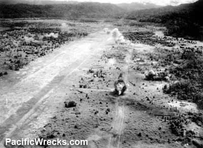
Wartime History
Used by Japanese Army Air
Force (JAAF) as a base for Ki-43 Oscars. Attacked by Allied aircraft in lat May 1944 until the end of October 1944 and neutralized as an airfield. Occupied by the Japanese until the official surrender of Japan in September 1945.
American missions against Ransiki
May 31, 1944–October 29, 1944
Today
Still in use today as "Ransiki Airport" or "Abresso Airport". Airport codes: ICAO: WASC, IATA: RSK.
References
Index to Air Bases - Research Report No. 85, I.G. No 9185 - July 30, 1944
Contribute
Information
Do you have photos or additional information to add?
Last Updated
April 19, 2025
|