|
|
|
|
| Missing In Action (MIA) | Prisoners Of War (POW) | Unexploded Ordnance (UXO) |
| Chronology | Locations | Aircraft | Ships | Submit Info | How You Can Help | Donate |
|
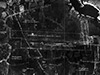 USAAF Sept 13, 1944 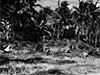 U.S. Army April 1945 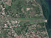 USAAF Sept 13, 1944 |
Location Lat 9° 20' 1N Long 123° 18' 2E Dumaguete Airfield is located at an elevation of 15' above sea level to the north of Dumaguete (Dumaguete City) in Negros Oriental Province on the southeast coast of Negros Island in the Central Visayas Region (Region VII) in the Philippines. Also known as Sibulan Airfield for Sibulan further to the north. Construction During late 1936 and early 1937, aerial photographs were taken of this area near the coast was selected for Dumaguete Landing Field. During 1938, the Philippines government with supervision and guidance from the U.S. Army Air Corps (USAAC) built a single runway oriented roughly north to south that measured 2,100' x 500' for use by civilian and military aircraft that was completed by March 1939. After the Japanese built two new runways nearby, this runway became known as the "Old Airstrip". During the Japanese occupation of Negros in 1942, they constructed two parallel runways oriented east to west each measuring 4,300' x 500'. The northern runway was the main strip and the southern runway was an auxiliary strip. By the middle of September 1944, revetments were under construction to the northwest and south of the runways plus a barracks area to the south. Wartime History Used by the Japanese as a military airfield. Between June 1944 to July 1944 based the 31st Kyoiku Hikotai an operational training unit flying Ki-79 Willow, Ki-36 Ida, Ki-55 Ida and Ki-54 Hickory. By late 1944, Dumaguete became more active after the U.S. landings on eastern Leyte and was used to disperse aircraft Imperial Japanese Navy (IJN) and Japanese Army Air Force (JAAF) aircraft from airfields elsewhere on Negros or a field to disperse aircraft. By July 30, 1944, the U.S. classified this airfield as an emergency landing strip. Japanese units based at Dumaguete 31st Kyoiku Hikotai (Ki-79, Ki-36, Ki-55 and Ki-54) arrives June 1944–July 1944 Between November 1944 to December 1944 attacked by American bombers and fighters that neutralized the airfield. Afterwards, abandoned by the Japanese with several aircraft disabled on the ground. American missions against Dumaguete November 11, 1944–December 19, 1944 During the middle of April 1945, Dumaguete Airfield was liberated by U.S. Army troops from the 40th Division reconnaissance elements and Americal Division, 164th Regimental Combat Team (164th RCT) that advanced from Sibulan southward to occupy the area. At the airfield, they found the wreckage of Japanese aircraft including the wreckage of a burned out D3A2 Val Tail 761-96 from 761 Kokutai (761 Air Group). At Dumaguete Airfield, Allied Technical Intelligence Unit (ATIU) noted the wreckage of one Ki-84 Frank and eight Ida. Today Still in use today as Dumaguete Airport. Postwar, the eastern end of the runway was extended with land fill beyond the natural coastline. The single runway follows the orientation of the the Japanese built runways is oriented 27/09 measures 6,136' x 118' surfaced with asphalt. Airport codes: ICAO: RPVD IATA: DGT. References Index to Air Bases - Research Report No. 85, I.G. No 9185 - July 30, 1944 ATIU Intelligence Summary No. 281 "Planes Recovered on Airfields" July 21, 1945 page 27 via Tony Feredo "Dumaguete A/D, Negros: Frank - 1, Ida - 8" Reports of General MacArthur - The Campaigns of MacArthur in the Pacific Volume I - Chapter XI Operations of the Eighth Army in the Southern Philippines pages 343, 345 (map), 347 Thanks to Tony Feredo for additional information Contribute
Information Last Updated
|
Map April 1945 Map Fallingrain |
| Discussion Forum | Daily Updates | Reviews | Museums | Interviews & Oral Histories |
|