|
Location
Lat
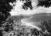
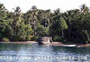
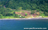
6° 49' 60S Long 155° 43' 60E Kangu is located on the southern coast of Bougainville Island. Also known as Kangu Beach. Borders Erventa Harbor (Buin Harbor). To the north is Kangu Hill (Mount Buin) and beyond Malabeta Hill (Malabita). To the southwest is Moila Point and to the northeast is Lamuai and Kahili (Buin). During the Pacific War, the Japanese referred to this area of the southern coast as "Buin". Prewar and during the Pacific War part of the Northern Solomons. Today located in the Buin Rural LLG, Autonomous Region of Bougainville (AROB) in Papua New Guinea (PNG).
Wartime History
During early 1942 occupied by the Japanese. During the Pacific War, Kangu beach and the coastline was heavily fortified with concrete bunkers, pillboxes, metal pillboxes, tunnels, coastal guns and anti-aircraft defenses. The beach area was rigged with explosives and offshore were sea mines. Starting in September 1943 attacked by U.S. bombers and fighters until the end of 1944.
American missions against Kangu
September 26, 1943–October 1, 1944
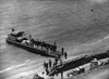
Occupied by the Japanese until their official surrender of Japan in September 1945. During late September 1945, this area was occupied by the Australian Army, 2 Corps, headquarters and ANGAU. During early October 1945, Japanese Prisoners Of War (POW) from southern Bougainville were assembled at Kangu before being transported aboard landing craft to Fauro Island where they were detained at a POW Camp.
Today
Postwar, Buin-Kangu Hill Road connects to Buin roughly 12km to the north. During 1991, during the "Bougainville Crisis", a
battle did occur at this location when the Papua New Guinea Defense Force (PNGDF) established a camp at this location and were attacked by rebels from the Bougainville
Revolutionary Army (BRA)
suffering twenty killed.
During
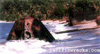
2002, an AusAid (Australian Aid) project to build a wharf at Kangu began construction. In preparation, MilSearch was contracted to search for and dispose of explosives in the area. Their search discovered many buried 7.7mm rifle cartridges, 140mm
shells and a line of buried depth charges, presumably for detonation in the event of an Allied landing at this location. These UXO munitions were carefully collected and detonated prior to the start of construction.
140mm Naval Gun Type 3 (1914) "Sea Coast Gun" No. 1
Eastern edge of Kangua Beach
140mm Naval Gun Type 3 (1914) "Sea Coast Gun" No. 2
Western edge of Kangua Beach
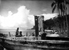
Generator Bunker
Built by the Japanese as a generator bunker. Postwar, the bunker was used as a jail by the Australian administration. The outer door
is missing. Above the doorway is an Imperial Japanese Navy anchor. The interior of the bunker is in excellent condition. Inside is the remains of of machinery inside.
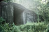
Pillboxes and Tunnels
Several large concrete pillbox over looks the beach, and tunnels
are carved into the hillside road to Kangu Hill (Buin Mountain).
Metal
Pillboxes
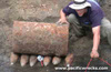
On the beach are several pyramid shaped metal pillboxes. Each has several shooting ports, and a tank-like turret entry hatch on the top. As of the 1970s, storms and beach erosion left them on the shoreline or filled with sand.
Erventa Harbor (Buin Harbor)
Erventa Harbor spans from Kangu to Kahili. The Japanese called this location "Buin Harbor".
Mine Field
Japanese and Americans mined
Erventa Harbor and approaches. By the middle of 1943, the Japanese minefields were beginning to break up. PT Boats observed and destroyed 50 mines in the area during July, August & September. American aircraft also laid mines at night from low
flying Avenger aircraft from VT-11 and VMSB-143 A number of Avengers were shot down in this manner. In 1944, US Navy fast mine layers also
made a run through the area. After the war, the Australian Navy cleared
this mine field. But locals reported yellow stains in the water where
mines still lay. A 1956 map (revised 1969) of the area lists the
area of water east of Shortland Island and north of Faisi to be
a 'Former Mined Area'.
Hatsuyuki
Sunk July 17, 1943 off Buin shipwrec was heavily salvaged
Nisshin
Sunk July 22, 1943 roughly sixty miles east of Buin
Contribute
Information
Do you have photos or additional information to add?
Last Updated
March 20, 2022
|