|
|
|
|
| Missing In Action (MIA) | Prisoners Of War (POW) | Unexploded Ordnance (UXO) |
| Chronology | Locations | Aircraft | Ships | Submit Info | How You Can Help | Donate |
|
 Robert Laessig c1944 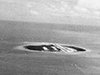 USAAF c1944 |
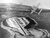
Location Lat 0° 31' 0S Long 132° 4' 0E Middleburg Island is part of the Su Islands or Soe Island Group located off the northern coast of western New Guinea. To the northwest is Amsterdam Island (Mios Su). To the south is Sansapor (Sausapor) on the north coast of western New Guinea. Prewar and during the Pacific War part of Dutch New Guinea (DNG) in the Netherlands East Indies (NEI). Today, part of the Tambrauw Regency in West Papua Province in Indonesia. Wartime History On July 30, 1944 at 7:30am an amphibious force from Task Force Typhoon (TF Typhoon) comprised of U.S. Army 6th Cavalry Recon Troop with a mortar section and riflemen of 1st Bn, 163d Infantry Regiment lands on Middleburg Island without opposition then moves to Amsterdam Island (Mios Su) without opposition. General Sibert takes command ashore at 10:20am. Occupied by the U.S. Army and developed into an airfield operational by August 15, 1944. Beginning in August 23, 1944 PBY Catalinas from VP-11 operated from Middleburg Island with PBY Catalinas. One September 1 1944,: VP-33 moved to Middleburg Island to conduct night search and attack missions against enemy shipping in the Netherlands East Indies (NEI) and southern Philippine Islands. On August 1, 1944 PT Boats begin operating from Amsterdam Island while Landing Craft Infantry (LCI) are shuttling aviation engineers and equipment to Middleburg Island to begin construction of Middleburg Airfield a location deemed to be a more suitable than locations on the Vogelkop Peninsula of western New Guinea. Today Middleburg Island is inhabited by a few families that tend the coconut palms and harvest copra. The island has the remains of jetties, pontoons and other remains from the wartime use. Middleburg Airfield (Klenso, Toem) Built by U.S. Army spans the length of Middleburg Island References Pub. 164 Sailing Direction (Enroute) New Guinea page 109 Contribute Information Do you have photos or additional information to add? Last Updated November 17, 2025 |
Map Mapcarta |
| Discussion Forum | Daily Updates | Reviews | Museums | Interviews & Oral Histories |
|