 |
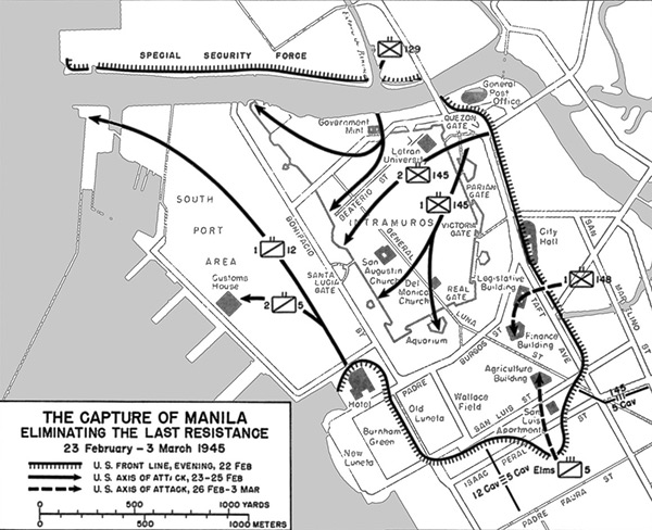
Map of the Capture of Manila Eliminating the Last Resistance 23 February-3 March 1945
The map shows southern Manila to the south of the Pasig River bordering Manila Bay. The hatched line indicates the U.S. Army front line "Special Security Force" on the evening of February 22, 1945. The solid line indicates the U.S. Army axis of attack February 23-25, 1945. The dotted line indicates the U.S. axis of attack February 26, 1945 to March 3, 1945. At the center is Intramuros District with Intramuros (The Walled City) with San Augustin Church (Church of San Agustin) and Del Monica Church. At the lower edge is Ermita District is Manila Hotel, Burnham Green (Rizal Park), Old Luneta, Wallace Field, Agriculture Building, Finance Building (National Museum of the Philippines) and Legislative Building, City Hall, Government Mint, General Post Office. At the center is the Port Area District is to the west with Customs House bordering Manila Bay.
Credit: Chapter XV The Drive Towards Intramuros page 298 Date: February 23-March 3, 1945
Map
High Resolution Version
Acquire This Image |
Contribute Information
Do you have photos or additional information?
Previous Page
|
|