|
|
|
|
| Missing In Action (MIA) | Prisoners Of War (POW) | Unexploded Ordnance (UXO) |
| Chronology | Locations | Aircraft | Ships | Submit Info | How You Can Help | Donate |
|
 Porter April 22, 1945  Justin Taylan 2003  Justin Taylan 2003 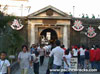 Justin Taylan 2003 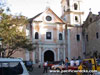 Justin Taylan 2003 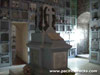 Justin Taylan 2003 Justin Taylan 2005 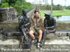 Justin Taylan 2005 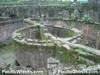 Justin Taylan 2005  Justin Taylan 2005 |
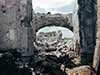
Location Lat 14° 35' 26N Long 120° 58' 33E Intramuros is located at an elevation of 9' / 2m above sea level in the Intramuros District in the 5th District of southern Manila in the in the National Capital Region (NCR) on Luzon in the Philippines. In Latin Intramuros means "within the walls". Also known as "The Walled City". When originally built during the Spanish colonial era, this location bordered Manila Bay. To the north is the Pasig River. During the early 1900's land reclamations to build the port area extended the shoreline westward. Postwar, Intramuros was rebuilt and remains one of the largest and most obvious Spanish era structures in Manila and is a popular tourist destination. Construction On June 24, 1571 Legazpi declared Manila to be the new capital of the Spanish colony. At this location, the Spanish first built Nuestra Señora de Guia (Fort Santiago) as the first stone fort with a circular layout to defend Manila and Manila Bay from foreign invasion. The Spanish colony raised funds for a stone wall to enclose the fortification by taxing Chinese goods for two years, monopoly on playing cards and gambling fines. Starting in 1589, plans for an outer stone wall including Fort Santiago began under the direction of architects Geronimo Tongco and Pedro Jusepe. By 1590 construction began over many years and varied as they were built under the administrations of different governor-generals including Juan Niño de Tabora starting in 1626 and Diego Fajardo Chacón starting in 1644 who built Baluarte de San Diego (San Diego Bastion). When completed, the outer stone outer wall was 40' thick at the base, 16-22' tall and roughly 20' wide at the top. Surrounding Intramuros was a double moat with the Pasig River forming a natural barrier on the northern side. The fortification was defended with cannons and infantry. The outer stone wall enclosed 64 hectares of buildings, military infrastructure and the Church of San Agustin. The Spanish worked to expand and improve Intramuros as a fortification until fully completed in 1872. Wartime History On August 13, 1898 after the Battle of Manila during the Spanish-American War, the Spanish surrendered and the U.S. flag was raised over Fort Santiago in Intramuros. During the American colonial era, Intramuros Ayuntamiento (City Hall) was the seat of the Philippine Commission. In 1901, Fort Santiago became the headquarters of the U.S. Army Philippine Division. In 1903, the walls from Santo Domingo Gate up to Almacenes Gate were removed with the stones used to build other structures in Manila and the wharf on the Pasig River was improved. During the American era, four openings were added to the wall to improve access. At the southwest end at Calle Aduana (Andres Soriano Jr. Avenue) and at the eastern side Calle Anda and at the northeast Calle Victoria (Calle de la Escuela) and at the southeast Calle Palacio (General Luna Street). During the land reclamation in the American era and construction of other buildings nearby meant Intramuros was no longer located at the edge of Manila Bay and the view obscured by the Port of Manila, Manila Hotel and Rizal Park. The moats were deemed unsanitary and filled with mud dredged from Manila Bay during the construction of the Port of Manila and became a municipal golf course. In the 1930's the building at No. 1 Victoria Street in Intramuros became the headquarters for U.S. Army Forces in the Far East (USAFFE) under the command of General Douglas MacArthur. After the start of the Pacific War and Japanese landings on Luzon and advance southward. On December 24, 1941 abandoned as a headquarters when Manila was declared an Open City and U.S. forces withdrew to the Bataan Peninsula. On January 2, 1942 Manila and Intramuros were occupied by the Japanese. During the Japanese occupation of the Philippines, the Japanese used the buildings in Intramuros including building at No. 1 Victoria Street as a barracks. In preparation for the defense of Manila against the expected American liberation, Intramuros was fortified by the Japanese with defenses and 120mm guns to defend Intramuros. Despite the fact that Imperial Japanese Army (IJA) 14th Area Army commander General Tomoyuki Yamashita order his forces to abandon Manila in favor of defending the mountains of northern Luzon, the Imperial Japanese Navy (IJN) under the command of Japanese Navy Rear-Admiral Sanji Iwabuchi opted to remain in the city and planned to defend ferociously with approximately 20,000 personnel. During the Battle of Manila in late February 1945 the surviving Japanese personnel from the Manila Naval Defense Force planned a fanatical defense from inside the walls of Intramuros and deliberately detained civilians, clergy and nuns as hostages. During the Battle of Manila, some indirect artillery fire was directed at Intramuros against gun positions and mortars. On February 17, 1945 the first deliberate U.S. artillery bombardment by XIV Corps began with 8' howitzers firing at the eastern wall firing 150 high explosive shells that created a breech between the Parian Gate and Victoria Gate. Later, a 155mm howitzer from the 756th Field Artillery fired at the south wall near Quezon Gate firing 150 rounds from 800 yards away that created a 50' break roughly 10' from the top of the wall. Next, a 8" howitzer fired at this hole to widen it with debris forming a ramp. On February 22, 1945 the 8" guns began firing at the north wall near the Government Mint and supported by 76mm firing from the north side of the Pasig River at nearly point blank range and continue firing into the night and until the early morning of February 23, 1945 to support the infantry assault. In total, during the preliminary artillery bombardment against Intramuros, U.S. Army artillery expended 7,487 high explosive rounds, 300 armor piercing rounds and 116 smoke and white phosphorus rounds. To begin a breech in the stone wall, artillery rounds without fuses were found to penetrate the deeper before exploding and after openings were created high explosive shells with delayed fuze settings to expand the penetrations. On February 23, 1945 the U.S. Army 37th Division supported by tanks and self propelled guns began the infantry assault of Intramuros. As a result of the battle, most of the stone buildings and outer walls were damaged or destroyed. Today Postwar, Intramuros was slowly reconstructed by the Philippine military and funds from civic groups. On April 10, 1979 Philippine Presidential Decree No. 1616 created the Intramuros Administration (IA) to rebuild, redevelop and administer and preserve Intramuros. Intramuros is a popular destination for tourists and is the most prominent Spanish era structure in Manila. Nearly every building and street corner has a plaque related to its history, and damage during the war. The location is geared towards general tourism, although several relics, memorials and locations are also important parts of World War II history. Memorare Manila Located in the Plaza de Santa Isabel, on the corner of General Luna and Anda Streets. This memorial was dedicated in 1995. The statue commemorates St. Isabel caring for wounded during the battle of Intramuros. Puerta de Santa Lucia (Santa Lucia Gate) Puerta de Santa Lucia (Santa Lucia Gate) faces Malecon Drive, this is the entrance to Intramuros, built in 1603. The gate was destroyed during the battle for Manila to allow American tanks to enter Intramuros. Its side chambers were restored in 1968, and the gate in 1982. Today, it is passable for foot traffic and storage of Spanish era related artifacts for festivals. Church of San Agustin The oldest stone church in the Philippines, built between 1586–1607. After the Spanish-American War, the terms for the American occupation of Manila were prepared in the vestry of the church in 1898. In 1993, it was chosen as a UNESCO world heritage site. Memorial for the Clergy & Civilians Killed Inside the church's crypt, there is a memorial and plaque to honor the 140 civilians and clergy killed by the Japanese during the fighting inside Intramuros on February 10, 1945. Cuartel De Santa Lucia (Santa Lucia Barracks) Built in 1781 as Cuartel de la artilleria de montana. Used as a barracks for the Philippine Constabulary beginning in 1901, then officer's school in 1905 until the school transferred to Baguio in 1908. Destroyed during the fighting during 1945, the remaining walls were used to reconstruct the barracks. No. 1 Victoria Street (Headquarters USAFFE) The building at No. 1 Victoria Street in Intramuros and Reducto San Pedro was used as the headquarters of the U.S. Army Forces in the Far East (USAFFE) under the command of General MacArthur. On December 24, 1941 abandoned as a headquarters when Manila was declared an Open City and U.S. forces withdrew to the Bataan Peninsula. On January 2, 1942 Intramuros were occupied by the Japanese and during the Japanese occupation used as a barracks building. During February 1945, destroyed during the Battle of Manila. Today, a pair of statues representing General MacArthur and Filipino mark the spot plus a memorial plaque. San Diego Bastion (Barbette San Diego, Bastion de San Diego) Located at the corner of Intramuros, built by the Spanish. This fortification is shaped like the 'ace of spades' and used as a foundry. During World War II, this structure was mostly destroyed. Today, it remains as ruins. 120mm Dual Purpose Gun (Type 10) Emplaced in the wall of Intramuros, still in situ today 120mm Dual Purpose Gun (Type 10) Emplaced in the grass area outside Intramuros Polverin (Power Magazine) Located near San Diego Bastion in Intramuros. Used by the Spanish for gunpowder storage for Intramuros. Later, gunpowder was moved to Fort San Antonio Abad for safety reasons. References U.S. Army in World War II - Triumph in the Philippines Chapter XIV: The End of an Era pages 234 U.S. Army in World War II - Triumph in the Philippines Chapter XV The Drive Towards Intramuros pages 271-290 U.S. Army in World War II - Triumph in the Philippines Chapter XVI Manila: The Last Resistance pages 291-303 U.S. Army in World War II - Section IV The Final Phase pages 343, 345, 346, 347 Contribute
Information Last Updated
|
Map Feb 23, 1945 Map Fallingrain Photo Archive |
| Discussion Forum | Daily Updates | Reviews | Museums | Interviews & Oral Histories |
|