Missing In Action (MIA)
Prisoners Of War (POW)
Unexploded Ordnance (UXO)
Chronology
Locations
Aircraft
Ships
Submit Info
How You Can Help
Donate
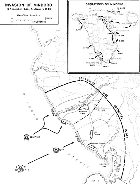
Map of the Invasion of
Mindoro
(Main map) Indicated is
San Jose
on the southwest corner of
Mindoro Occidental
on
Mindoro Island
bordering
Mangarin Bay
and
Mindoro Strait
. Indicated is
Old San Jose Airfield
,
Elmore Field
,
Hill Drone
and
Atkinson Drome (San Jose Airfield, McGuire Airfield)
. The black arrows indicate the amphibious landing of U.S. Army soldiers from the 503rd 503d Parachute Regimental Combat Team (503rd Parachute RCT) at Green Beach and Blue Beach on each side of the Bugsanga River. Further south the 19th Regimental Combat Team (19th RCT) with Task Force Reserve landing at White Beach. The dotted line indicates the beachhead line outpost position as of December 15, 1944.
(Upper Inset)
Operations on Midoro Island
with U.S. landing dates indicated.
Credit: U.S. Army Date:
December 15, 1944
–
January 31, 1945
Map
High Resolution Version
Acquire This Image
|
Contribute Information
Do you have photos or additional information?
Previous Page
Discussion Forum
Daily Updates
Reviews
Museums
Interviews & Oral Histories
Pacific Wrecks Inc.
All rights reserved.