|
|
|
|
| Missing In Action (MIA) | Prisoners Of War (POW) | Unexploded Ordnance (UXO) |
| Chronology | Locations | Aircraft | Ships | Submit Info | How You Can Help | Donate |
|
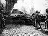 U.S. Army Dec 22, 1944 |
Location Lat (DMS) 11° 12' 60N Long (DMS) 124° 34' 13E Lonoy (Tonoy) is located at an elevation of 150' / 45m inland from the north coast of Leyte Island in Leyte Province in the Eastern Visayas (Region VIII) in the Visayas (Visayas Islands) in the central Philippines. Also spelled Tonoy. The Ormoc-Limon Road (Highway 2) spans Limon connecting northward to Limon (Lemon) and south to Kananga. To the east is Mount Cabungaan (Mt. Cabungaan). Wartime History On December 15, 1944 the U.S. Army, 12th Cav Regtiment, 1st Sq (-) advances west toward Highway 2 and reaches a previously selected drop area, a banana plantation about 1,800 yards east of Lonoy. On December 19, 1944 the 12th Cav captures Lonoy. On December 22, 1944 the U.S. Army, 32nd Infantry Division, 127th Infantry Regiment advances southward on Highway 2 towards Lonoy supported by four M4 Sherman tanks from 44th Tank Battalion. On the road, a pair of Type 95 Ha Go tanks attempted to engage the leading M4 Sherman but are both destroyed by hits from the Sherman's 75mm main guns. Destroyed is the lead Type 95 Ha Go tank (Lonoy No. 1) and Type 95 Ha Go (Lonoy No. 2). The pair of taks block the road until pushed aside by a bulldozer allowing the advance to continue south towards Kananga where they make contact with the 112th Cavalry Regiment approximately 3,000 yards south of Lonoy. References U.S. Army in World War II Leyte: The Return to the Philippines Chapter XIX The Entrances to Ormoc Valley pages 325, 326, 237 (photos), 328 U.S. Army in World War II Leyte: The Return to the Philippines Chapter XX pages 342, 343, 344 History of the 127th Infantry Regiment, Wisconsin National Guard in World War II (1946) page Leyte 15 "The four tanks of the 44th Tank Battalion working on the road are to be commended. They worked aggressively and knocked out all pockets of resistance encountered. Assisted by the infantry, 11 tanks and two gun carriers were knocked out. Shortly after the attack started, the leading tank was rushed by a Jap tank [this tank]. Or tank opened fire and destroyed the Jap tank, but this enemy tank blocked further advance of our tanks, because it could not be bypassed The Service Company bulldozer was called upon. The bulldozer cam forward, the driver being very anxious to get his chance at the enemy. He moved in front of our tanks, and disregarding enemy sniper fire, pushed the Jap tank [this tank] over the side of the hill. He then allowed our first two tanks to pass him and joined the column down the road." Contribute
Information Last Updated
|
Map December 1944 Map December 1944 Lonoy Map Fallingrain Map Mapcarta |
| Discussion Forum | Daily Updates | Reviews | Museums | Interviews & Oral Histories |
|