|
|
|
|
| Missing In Action (MIA) | Prisoners Of War (POW) | Unexploded Ordnance (UXO) |
| Chronology | Locations | Aircraft | Ships | Submit Info | How You Can Help | Donate |
|
 Justin Taylan 2005 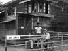 Carl R. Thien 1945 |
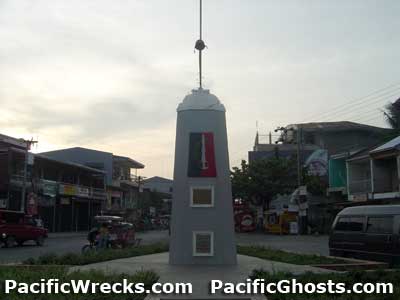
Location Lat 15° 53' 40N Long 120° 37' 58E Rosales is a municipality at an elevation of 95' / 28m in the 6th District (District IV) in the southeast of Pangasinan Province in the Ilocos Region (Region I) of northern Luzon in the Philippines. To the north is the Ango River and beyond Villasis. To the west is is Rosales Airfield (Carmen), the MacArthur Highway and beyond Carmen. Wartime History On December 26, 1941 occupied by the Japanese Army. During the Japanese occupation, they operated a rice mill and used the town hall and other buildings and residences to garrison soldiers. On January 19, 1945 liberated by the U.S. Army without resistance. After liberation, it became an American camp area. American units based in Rosales 201st Counter Intelligence Corps (201st CIC) Are you a veteran that was station in Rosales? to share your experiences Postwar, a number of buildings were demolished, the central park dug up and large trees in the market cut down in an attempt to find "Japanese gold" stashed in the trunks. Of course, all of these searches found nothing. The town's mayor at the time was criticized for working with treasure hunters, and destroyed the town's history. Unknown Soldier's Shrine Located in the center of town, this monument had fallen into disrepair. In June 2005, the monument was rehabilitated and rededicated by Mayor Revita and funds from Rosales Association of Southern California. The plaque reads: "In Memory of the valiant and noble heroes who courageously fought and offered their lives for us to be free" CIC House Civilian house occupied by the 201st Counter Intelligence Corps (201st CIC) after the town was liberated. This building still remains today, but was damaged during a typhoon in 2008. Then & Now Photographs. Mount Balungao Mountain to the south of Rosales, visible from town Contribute
Information Last Updated
|
Map District Map Province Map Fallingrain Map Mapcarta |
| Discussion Forum | Daily Updates | Reviews | Museums | Interviews & Oral Histories |
|