|
|
|
|
| Missing In Action (MIA) | Prisoners Of War (POW) | Unexploded Ordnance (UXO) |
| Chronology | Locations | Aircraft | Ships | Submit Info | How You Can Help | Donate |
|
 USAAF c1944-1945 |
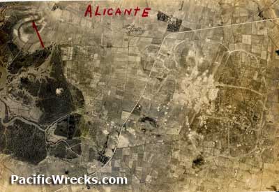
Location Lat 10° 52' 39N Long 122° 58' 4E Saravia is is located at an elevation of 3' above sea level in Negros Occidental Province on the northwest coast of Negros Island in the Western Visayas (Region VI) in the Visayas (Visayas Islands) in the central Philippines. Today known as Enrique B. Magalona municipality. Also known as EB Magalona. To the northeast is Alicane and to the south is Silay. Saravia Airfield (Alicante Airfield) Japanese built airfield, abandoned since the war American missions against Alicante October 19, 1944–December 19, 1944 Contribute
Information Last Updated
|
Map Fallingrain Map Mapcarta |
| Discussion Forum | Daily Updates | Reviews | Museums | Interviews & Oral Histories |
|