|
|
|
|
| Missing In Action (MIA) | Prisoners Of War (POW) | Unexploded Ordnance (UXO) |
| Chronology | Locations | Aircraft | Ships | Submit Info | How You Can Help | Donate |
|
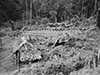 AWM April 9, 1944 |
Location Lat 9° 1' 0S Long 147° 43' 60E Eora Creek village is located at an elevation of 5,029' / 1,532m in the Eora Creek Valley (Eora Valley) along the Kokoda Trail in the Owen Stanley Range of New Guinea. Also spelled "Iora Creek". To the north is Alolo (Alola) and beyond Isurava. To the south is Templeton’s Crossing No. 2. Today located in Kokoda Rural LLG, Sohe District of Oro Province in Papua New Guinea (PNG). Prewar Eora Creek village was a small settlement with a dozen huts in a clearing on a ridge of a spur roughly 300' above a stream. At the start of the Pacific War, the village was abandoned and never reestablished. Wartime History At the start of the Kokoda Campaign, Eora Creek was used as a camp area by the Australian Army known as "Eora Camp" with a dump area. On August 24, 1942 an ADS was established here and later a Regimental Aid Post (RAP) under the command of Major J. Rupert Magarey from the 2/6th Field Ambulance to treat casualties from the Battle of Isurava. During late August 1942, Australian reporters Osmar White (Melbourne Herald) and Chester Wilmot plus war correspondent and cameraman Damien Parer were at Eora Creek village. Parer recorded several still photos before discarding his camera and shot cine footage used in "Kokoda front line". White and Wilmot reported on the casualties and efforts by surgeons and orderlies in primitive conditions to treat the wounded and perform amputations and advanced to Alolo as the Australians withdrew back to this location. Between August 29-30, 1942 the remaining Australians from 2/14th Battalion and 39th Battalion withdrew to Eora Creek village as the Japanese advanced southward. By August 31, 1942 the Australian Army established a rearguard position to the north of the village digging weapons pits with the 39th Battalion on the ridge above the creek as the 2/16th Battalion withdrew and were ordered to destroy a log crossing once they had crossed. Battle of Eora Creek September 1-2, 1942 On September 3, 1942 the Japanese occupied the area and used it as a staging base for their advance southward along the Kokoda Trail. During early September 1942 attacked by Allied aircraft. American missions against Eora Creek (Iora Creek) September 6, 1942 Following the Japanese withdrawal northward, this area was developed with defenses against the advancing Australians. To defend the Eora Creek area, the Japanese established strong defensive positions at Etoa (aka "Lost Battlefield" or "Japanese Forest Fort") on a ridge overlooking the area supported by machine guns and rifle pits plus a single mountain gun and two mortars with access to a supply of fresh water. By late October 1942, Australian Army soldiers advanced from Templeton's Crossing No. 2 towards the Eora Creek village area by late October 1942. Battle of Eora Creek October 22-29, 1942 Eora Creek War Cemetery Established at this location for casualties from the 2/1st Infantry Battalion during October 1942. Today A memorial is located at Eora Creek. References Australian Army 2/6th Field Company Engineers Track Report - September 1942 "Eora Creek approximately a dozen natives huts in open clearing situation on ridge of a spur approx 300 ft above a swift stream." AWM - Eora Creek AWM "Kokoda front line [unedited]" F01212 includes footage at Eora Creek village August 28, 1942 Field Guide to the Kokoda Track by Bill James (2006) pages 285 (map), 294 (map), 295 (profile map) 298-306 (Eora Creek), 301 (Australian casualties Eora Creek withdrawal - September 2-3, 1942), 303 (map Battle of Eora Creek October 27-28, 1942), 307-308 (Australian casualties Eora Creek casualty list - October-November 1942), 309-310 (Parer photo then & now), 312 (map Eora Creek village to Isurava), 313 (profile map: Eora Creek village to Isurava battle site) Hell's Battlefield (2012) by Phil Bradley pages 44 (map), 48 (map profile), 52-53, 56-59, 93-98, 489 (index) Contribute
Information Last Updated
|
Map Kokoda Trail Map Oct 27-28, 1942 Map Fallingrain |
| Discussion Forum | Daily Updates | Reviews | Museums | Interviews & Oral Histories |
|