|
|
|
|
| Missing In Action (MIA) | Prisoners Of War (POW) | Unexploded Ordnance (UXO) |
| Chronology | Locations | Aircraft | Ships | Submit Info | How You Can Help | Donate |
|
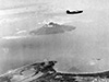 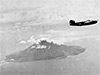 5th AF c1943 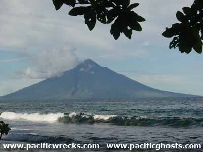 Justin Taylan 2003 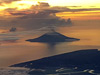 Keith Hopper 2016 |
Location Manam Island is an active volcanic cone island off the north coast of New Guinea. The peak of the volcano is 4,265' / 1,300m elevation. To the southwest is Stephan Strait and Hansa Bay. To the west is Awar Point (Condor Point). To the northwest is Boisa Island. Prewar and during the Pacific War located in the Territory of New Guinea. Today located in Madang Province in Papua New Guinea (PNG). Wartime History During early 1943, occupied by the Japanese Army. During 1943–1944 Manam Island was targeted by Allied bombers and fighters. On May 29, 1943 heavy and medium bombers, operating individually or in flights of two bombers, attack targets including Manam Island. On March 7, 1944 during the early morning, PT-337 was sunk in Hansa Bay with the crew in a life raft drifted towards Manam Island. Several of the crew attempted to swim to the island to locate food and water but spotted Japanese ashore and returned to their life raft. On March 11, 1944 five of the surviving crew were rescued by a PBY Catalina that landed off Manam Island to rescue them escorted by two P-47 Thunderbolts. Today During the late 1990s, Manam erupted ash. References Pub. 164 Sailing Direction (Enroute) New Guinea (1994) page 220 Contribute
Information Last Updated
|
Map Fallingrain Photo Archive |
| Discussion Forum | Daily Updates | Reviews | Museums | Interviews & Oral Histories |
|