|
|
|
|
| Missing In Action (MIA) | Prisoners Of War (POW) | Unexploded Ordnance (UXO) |
| Chronology | Locations | Aircraft | Ships | Submit Info | How You Can Help | Donate |
|
 5th AF January 12, 1944  RAN April 27, 1944 |
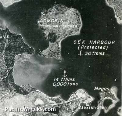
Location Sek Harbor borders the north coast of New Guinea. Also known as Alexishafen Harbor or Alexis Harbor for nearby Alexishafen. The eastern edge is formed by Sek Island. Inside Sek Harbor are Admosin Island and Megas Island with Bostrem Bay at the western edge. Borders Alexishafen to the south. The average depth and 14 fathoms / 84' / 25.6m. The maximum depth is 30 fathoms / 180' / 54.8m. Prewar and during the Pacific War part of Madang District in the Territory of New Guinea. Today located in Madang Province in Papua New Guinea (PNG). Wartime History In late December 1942, occupied by the Japanese Army. During the Japanese occupation, used as an anchorage with shore facilities on the peninsula of Alexishafen bordering Alexishafen Mission. In late April 1944 when the Australian Army liberated Alexishafen, Sek Harbor was used by Allied vessels and was deemed suitable for vessels up to 6,000 tons. On April 24, 1944 Sek Harbor was used by HMAS Bundaberg (J231) that landed a platoon on Sek Island then docked at the remains of the wharf at Alexishafen. On April 27, 1944 a U.S. Navy (USN) PT Boat entered Sek Harbor. Allied units based at Alexishafen (Sek Harbor) (US Army) 3rd ESB, 593rd Boat & Shore Regiment, Company C attached to Australian 5th Division to support operations in the area between April 1944–May 1944 Contribute
Information Last Updated
|
Map Jan 16, 1944 Map Mapcarta |
| Discussion Forum | Daily Updates | Reviews | Museums | Interviews & Oral Histories |
|