|
|
|
|
| Missing In Action (MIA) | Prisoners Of War (POW) | Unexploded Ordnance (UXO) |
| Chronology | Locations | Aircraft | Ships | Submit Info | How You Can Help | Donate |
|
 Justin Taylan 2005 |
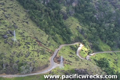
Location The Sogeri Road begins at 9 Mile near Port Moresby and follows the Laloki River to Sogeri. Built along the curving foothills and mountainside, the road weaves back and around itself. Also known as "Rouna Road" or "Snake Road" by the Australian Army. The road overlooks Rouna Falls. Prewar Originally, the road was a walking track. During the Colonial era, portions of the road were expanded for use by mules, horses and later automobiles. Wartime History During 1942, the road was expanded and improved by the Australian Army to facilitate the movement of vehicles, troops and supplies from Port Moresby to Owers' Corner at the start of the Kokoda Trail. During 1942–1943, many Australian Army and Royal Australian Air Force (RAAF) units were camped along the Sogeri Road, including hospitals, Salvation Army Red Cross stations and other support units. The road was used for the duration of the war. Many Allied personnel including Australian and Americans traveled along the road to visit Rouna Falls and to escape the hotter coastal climate. Today The Sogeri Road is still in use as the only road access from Port Moresby to Sogeri. Wartime U.S. Army marston matting (PSP) is still in use at some places as guard rails or gutters. References Snake Road details the Sogeri Road and is the definitive reference on this location Contribute Information Do you have photos or additional information to add? Last Updated February 23, 2026 |
Map Fallingrain Photo Archive |
| Discussion Forum | Daily Updates | Reviews | Museums | Interviews & Oral Histories |
|