 |
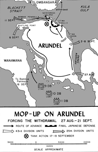
Map of mop-up on Arundel forcing the withdrawal 27 Aug.–21 Sept
Annotations include Arundel Island including Bustling Point, Bomboe peninsula, Stima peninsula, Sagekarasa Island, Stima Lagoon bordering Hathorn Sound, Blackett Strait, Kula Gulf and the southern edge of Kolombangara Island, Wanawana Island (Vonavona) and western edge of New Georgia in the central Solomon Islands.
The black arrows show the American routes of advance. The solid line with rectangular edges represents the final Japanese defense. The white arrow is 43rd Division units lands on August 27, 1943 on the Nauro peninsula on southeast of Arundel Island. The shaded arrow shows the 25th Division units that landed on the Bomboe peninsula and on September 13, 1943 swam to Sagekarasa Island.
The ⓧ represents the "tank action" September 17-19, 1943 by thirteen U.S. Marine Corps (USMC) tank 9 DB, 10 DB, 11 DB that landed September 16, 1943. The black dotted line shows the Japanese withdrawal September 19-20, 1943 to Kolombangara Island.
Credit: U.S. Army Date: August 27, 1943–September 21, 1943
Map
High Resolution Version
Acquire This Image |
Contribute Information
Do you have photos or additional information?
Previous Page
|
|