|
|
|
|
| Missing In Action (MIA) | Prisoners Of War (POW) | Unexploded Ordnance (UXO) |
| Chronology | Locations | Aircraft | Ships | Submit Info | How You Can Help | Donate |
|
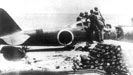   U.S. Army Signal Corps February 10, 1943 |
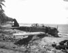
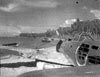
Location Lat 9° 19' 60S Long 159° 35' 60E Verahue is located to the southwest of Cape Esperance on the northwest coast of Guadalcanal. Borders a narrow channel fringed by coral reefs with a good beach. Also spelled Varhui, Verahui or Verabue. To the northeast is Titi and Maravovo. To the south is Nugu Point (Cape Nagle). Prewar and during the Pacific War part of the British Solomon Islands Protectorate (BSIP). Today located in Guadalcanal Province in the Solomon Islands. Wartime History On February 1, 1943 in the early morning schooner Kocorana commandeered by the U.S. Army landed a small group led by Major Butler at Nugu Point (Cape Nagle) and established an observation post with a radio for communication and reported the landing beach at Verahue was clear. Soon afterwards, USS Stringham APD-6 and five Landing Craft Tank (LCT) escorted by four destroyers and escorted by fighter aircraft landed an advance party that met Major Butler ashore. The main landing began with the amphibious landing of roughly 1,500 American personnel without opposition. The main force was the U. S Army Americal Division, 132nd Infantry Regiment, 2nd Battalion under the command of Col. Alexander M. George. Also regiment's Anti-Tank company, a portion of Weapons Company from the 3rd Battalion and one platoon of riflemen of Company K, 132d Infantry, Battery F, 10th Marines plus other communications, engineer, and medical personnel. By noon, Japanese bombers overflew the beachhead area but did not attack. By 3:00pm, all troops and equipment was successfully unloaded and all vessels and landing craft departed back to Lunga Anchorage. On February 2, 1943 in the morning the soldiers began advancing along the beach towards Titi with G Company and twenty native scouts covered the high ground at the right flank. Vehicles were able to drive along the beach and coastal area to bring up supplies. Afterwards, the force advanced along the coast towards Titi. A6M2 Zero Tail D1-158 Ditched or crashed during early 1943 A6M2 Zero Tail 114? Ditched or force landed January 25, 1943 wreckage captured by U.S. Army February 1, 1943 References The U.S. Army Campaigns of World War II Guadalcanal Introduction page 22 "Patch assembled a task force around the 2d Battalion, 132d Infantry, and sent it around the west end of the island by Navy landing craft to Verahue, ten miles southwest of Cape Esperance." U.S. Army in World War II - Guadalcanal: The First Offensive Chapter XV: Final Operations on Guadalcanal United States Army in World War 2, Special Studies, Chronology, 1941-1945 page 90 Naval History and Heritage Command - The Guadalcanal Campaign by Major John L. Zimmerman page 162 U.S. Army Final Operations on Guadalcanal pages 343-345 Contribute
Information Last Updated
|
Fallingrain Map Aug 7, 1942 |
| Discussion Forum | Daily Updates | Reviews | Museums | Interviews & Oral Histories |
|