|
|
|
|
| Missing In Action (MIA) | Prisoners Of War (POW) | Unexploded Ordnance (UXO) |
| Chronology | Locations | Aircraft | Ships | Submit Info | How You Can Help | Donate |
|
 USN 1943 |
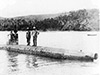
Location Lat 9° 17' 6S Long 159° 38' 9E Maravovo is located on the northwest coast of Guadalcanal. Borders Coughlan Harbor to the northeast and beyond Visale and Cape Esperance. Wartime American spelling "Marovovo". To the southwest is Verahue (Varhui, Verahui, Verabue). To the northeast is Visale. Prewar and during the Pacific War part of the British Solomon Islands Protectorate (BSIP). Today located in Guadalcanal Province in the Solomon Islands. Wartime History On October 7, 1942 the Japanese established a midget submarine base at Marovovo. On November 7, 1942 at 2:30pm HA-11 Type A Midget Submarine is run aground by the crew at this location and the crew rescued. Afterward, the submarine remains in shallow water near shore. On February 7, 1943 in the afternoon the U. S Army 132nd Infantry Regiment, 2nd Battalion reached Maravovo and bivouac for the night. The next morning, they continue to advance to the northeast to Kamimbo Bay. HA-11 Type A Midget Submarine Run aground November 7, 1942 References U.S. Army Final Operations on Guadalcanal pages 345-346 Sailing Directions for the Pacific Islands Volume I - Western Grups, including the Solomon Islands (1964 revised edition 1976) Sec 2C-14 page 114 Contribute
Information Last Updated
|
Map Aug 7, 1942 Map Fallingrain |
| Discussion Forum | Daily Updates | Reviews | Museums | Interviews & Oral Histories |
|