|
|
|
|
| Missing In Action (MIA) | Prisoners Of War (POW) | Unexploded Ordnance (UXO) |
| Chronology | Locations | Aircraft | Ships | Submit Info | How You Can Help | Donate |
|
 38th BG c1942-1943 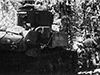  U.S. Army July 1943 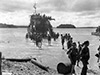 U.S. Army July 22, 1943 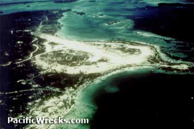 USAAF 1944 |
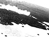
Location Lat 8° 20' 14S Long 157° 17' 11E Zanana Beach is 200 yards (600' / 182.8m) in length on the southern coast of New Georgia in the New Georgia Island Group (New Georgia Islands) in the central Solomon Islands. Also known as simply Zanana. Sometimes misspelled "Zanona". Borders Roviana Lagoon to the east and south and beyond offshore islands including Sasavele Island (Dume) to the southeast and Roviana Island to the south. Inland to the west is the Barike River. At this location began the Munda Trail a footpath westward to Munda. Prewar and during the Pacific War part of the British Solomon Islands Protectorate (BSIP). Today located in Western Province in the Solomon Islands. Wartime History By late June 1943, Allied coastwatchers and Solomon scouts reported the Zanana Beach area was not defended by the Japanese and was selected as a landing site for a portion of the U.S. "Western Landing Force" to seize a beachhead on the southern coast of New Georgia for the drive westward toward Munda. On July 2, 1943 the first Americans to land at Zanana Beach was U.S. Army, 43rd Infantry Division, 169th Infantry Regiment's A Company and found the beach clear and established a perimeter ahead of the main body. Zanana Beach was within range of 155mm artillery and 90mm anti-aircraft guns on offshore islands including Sasavele Island (Dume) and northern Rendova Island. On July 3, 1943 landings continues with reinforcements including U.S. Marine Corps (USMC) M3 Stuart light tanks and the 9th Defense Battalion, 10th Defense Battalion and 11th Defense Battalion. On July 4, 1943 1st Battalion, 172nd Infantry Regiment landed without difficulty. By July 6, 1943 both regiments were fully ashore and were advancing westward. Afterwards, the Zanana beach area became a staging area supporting the advance westward on the Munda Trail towards Munda. Later, expanded by the The 118th Engineer Battalion into a jeep trail. Today The beach area is still littered with debris from the war including the rusted metal rims of 55 gallon drums. References U.S. Army in WWII The Reduction of Rabaul Chapter VI Toenails: The Landings in New Georgia pages 72 (raider recon report), 92-94, 96 U.S. Army in WWII The Reduction of Rabaul Chapter VII The Offensive Stalls pages 97-98 U.S. Army in WWII The Reduction of Rabaul Chapter VIII Griswold Takes Over pages 135-137, 140 The U.S. Army Campaigns of World War II Northern Solomons pages 15, 16, 19 History of the U.S. Marine Corps Operations in World War II - Chapter 1 pages 45, 53-54 History of the U.S. Marine Corps Operations in World War II - Chapter 2 pages 87, 88 History of the U.S. Marine Corps Operations in World War II - Chapter 3 pages 89-91, 92 (map), 94-95 History of the Marine Corps Operations in World War II - Isolation of Rabaul Volume II (1963) pages 45, 53-54 Condition Red: Marine Defense Battalions in World War II - Into the Central and Northern Solomons Marines in World War II - The Munda Drive and the Fighting Ninth The Munda Trail (2000) pages 23, 28-29, 75-76, 82, 83 (July 2, 1943) 84, 85 (July 4-5, 1943), 86-89, 92-97, 101, 104-105, 109, 111, 115, 121, 140-142, 147, 151, 153, 167-168, 252 (index Zanana) Contribute
Information Last Updated
|
Map July 1943 Map Nov 15, 1943 Map Fallingrain Photo Archive |
| Discussion Forum | Daily Updates | Reviews | Museums | Interviews & Oral Histories |
|