|
|
|
| Missing In Action (MIA) | Prisoners Of War (POW) | Unexploded Ordnance (UXO) |
| Chronology | Locations | Aircraft | Ships | Submit Info | How You Can Help | Donate |
|
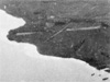 5th CCU January 5, 1943 |
Location Rapopo is located at Lesson Point on the north coast of the Gazelle Peninsula in New Britain. Borders Blanche Bay to the north and Kokopo to the west. Between 1884 until September 1914 part of Deutsch Neu Guinea (German New Guinea). Prewar and during the Pacific War part of the New Britain District in the Territory of New Guinea. Today located in East New Britain Province of Papua New Guinea (PNG). Prewar Rapopo Plantation (Kabakaul Plantation) planted with coconut palms harvesting copra spanned Lesson Point. To the east was Ulaveo Plantation. Two plantation houses were located at the northeast tip: Duncan's House and Randal's House and a small jetty. To the west was another plantation. Wartime History During late January 1942, occupied by the Japanese and developed into a base. During late 1942, Rapopo Airfield was built at this location. The runway was completed by January 1943. Between January 1943 until the end of the Pacific War, the Rapopo area was targeted by Allied aircraft. American missions against Rapopo January 26, 1943–June 23, 1944 Rapopo Airfield (Rabaul South, South Airfield) Japanese built airfield, abandoned since the war Contribute
Information Last Updated
|
Map March 12, 1943 Photo Archive |
| Discussion Forum | Daily Updates | Reviews | Museums | Interviews & Oral Histories |
|