|
|
|
|
| Missing In Action (MIA) | Prisoners Of War (POW) | Unexploded Ordnance (UXO) |
| Chronology | Locations | Aircraft | Ships | Submit Info | How You Can Help | Donate |
|
 Stuckey Nov 27, 1943 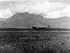 Australian Army May 19, 1944 |
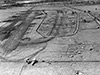
Location Lat 5° 51' 29S 145° 42' 18E Dumpu Airfield was located at an elevation of 870' above sea level to the northwest of Dumpu (Tumpu) in the Ramu Valley of New Guinea. Also spelled Tumpu. To the south was the Ramu River. To the north was the Faria River. Prewar and during the Pacific War located in Madang Distict in the Territory of New Guinea. Today located in Madang Province in Papua New Guinea (PNG). Construction Built prewar as a landing ground. During the middle 1942 Dumpu Airfield had a single runway 700 x 90 x 2,200 yards surfaced with hard dry grass with good approaches. Facilities included native houses and water but no food and native population that speak Pidgin English. The runway could be lengthened. Wartime History During March 1942, occupied by the Japanese. On October 4, 1943 the Dumpu area was occupied by the Australian Army. Afterwards, Dumpu Airfield was repaired and bulldozed for use by Allied planes as an emergency runway. The Dumpu Airfield area was defended by the Australian Army 2/4th Light Anti-Aircraft Regiment with Bofors 40mm guns. C-47 Skytrains and other transport aircraft used Dumpu Airfield to fly in supplies and evacuate wounded and sick personnel. By November 1943 detected by the Japanese and targeted by several air raids including November 6, 1943 and March 15, 1944. Japanese missions against Dumpu November 6, 1943–March 15, 1944 By December 1943 Dumpu Airfield was surveyed by U.S. Army engineers as all weather aerodrome with two parallel runways for use by fighter aircraft. On December 19, 1943 Lodestar A67-4 tail VH-RAD with passenger Australian Army General Sir Thomas Blamey aboard lands at Dumpu Airfield, met by Major General G. A. Vasey, commander 7th Australian Division. By January 8, 1944 only preliminary construction had begun, the expansion project was canceled due to policy decision that deemed a full airfield to be unnecessary at this location. Today Dumpu Airport remains in use as a landing groud. Airport code: IATA: DPU. No 1 Strip (East Base) This runway was located nearest to Dumpu and was roughly parallel to the Uria River. No 2 Strip (West Base) This runway was located to the north and parallel to the Ramu River and was surfaced with compacted earth. A line of dispersal areas were to the north of the runway and was located near the West Base area of Dumpu. P-40N Warhawk 42-105861 Fuselage section recovered in 1974 and shipped to United States P-40N Warhawk 42-104954 Fuselage section recovered in 1974 and shipped to United States C-47 Dakota Abandoned at Dumpu Airfield. References Notes about New Guinea airfields, recorded circa May - July, 1942 by Oliver C. Doan via Jean Doan research Edward Rogers Engineers in Theater Operations [Pacific] "Advance Area Airdromes 31 January 1944", Map No. 24 - 6,000' x 100' compacted, gravel & clay, usable earth strip Contribute
Information Last Updated
|
Map July 1943 Map 1944 Map Fallingrain Photo Archive |
| Discussion Forum | Daily Updates | Reviews | Museums | Interviews & Oral Histories |
|