|
|
|
|
| Missing In Action (MIA) | Prisoners Of War (POW) | Unexploded Ordnance (UXO) |
| Chronology | Locations | Aircraft | Ships | Submit Info | How You Can Help | Donate |
|
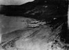 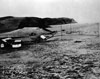  USN prewar 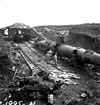 USN August 1943 |
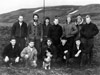
Location Kiska Island is located in the Rat Island Group (Rat Islands) in the Aleutian Island Chain (Aleutian Islands) in Alaska in the United States. To the west is Attu Island. Borders Kiska Harbor. To the east is Little Kiska Island. Prewar The U.S. Navy (USN) established Kiska Station (Kiska Weather Station) as a forward weather station manned by ten personnel led by a Lieutenant with their pet dog. Wartime History On June 6, 1942 five hundred Imperial Japanese Navy (IJN) No. 3 Maizuru Special Naval Landing Force (3rd Maizuru SNLF) land at Kiska Harbor. Ashore, they attacked the USN weather detachment killing two and capturing the others who were sent to Japan as Prisoners Of War (POW). One escaped and was able to evade capture for fifty days until he surrendered starving and thin from exposure. During the Japanese occupation, the Japanese Navy developed the area bordering Kiska Harbor, known as "Main Camp" including Kiska Harbor Seaplane Base with a seaplane operating area in Kiska Harbor. A submarine base was established with a ramp and pens for several mini submarines with anti-aircraft guns defended the area. The Japanese begin to transfer their garrison from Attu to Kiska. By July 28, 1943 the entire Japanese garrison of 5,183 troops and civilians was evacuated from Kiska by the Japanese Navy under the cover of fog. Despite massive American air and naval power in the vicinity, the evacuation force was not detected and the Allies were unaware the Japanese had withdrawn and continued bombing missions and plans for an amphibious assault. American missions against Kiska June 8, 1942–August 17, 1943 On August 15, 1943 an Allied force of U.S. Army and Canadian Army soldiers made an amphibious landing on Kiska. Quickly, they realize their are no Japanese defenders. Ashore, the Allied force suffers 17 fatalities and roughly 200 casualties from accidents, friendly fire and enemy booby traps left behind. Another 130 suffer injuries from trench foot. Today Kiska is considered a National Historic Landmark (the highest level of recognition accorded to historic sites in the US, and is protected). Around the harbor, is one of the best preserved historical scenes anywhere. The slow erosion processes on the tundra have had little effect on the bomb craters still visible on the hills surrounding the harbor. Dumps of US and Japanese material are numerous. Right-hand drive Japanese truck frames are piled up, along with zero engines and other evidence of Japanese occupation. Extensive support structures are in place, such as a water hydrant. Evidence of US troop occupation remains in both standing structures and collapsed ones. US; dump sites containing numerous 3-inch shells, debris and aircraft wreckage. Some of the most dramatic remains are the numerous tunnels from the extensive Japanese underground system, some concrete reinforced. Many are still sound and contain Japanese material. Trout Lagoon Located off Kiska on September 16, 1942 Nozama Maru was beached at this location. Gertrude Cove Located on the southern coast of Kiska, Borneo Maru ran aground on October 15, 1942. Quisling Cove Located on the northwest coast of the island. On August 15, 1943 the 1st Special Service Force landed at Quisling Cove onto Lilly Beach (Beach 9-Blue). The main landing by the 1st Battalion, 87th Mountain Infantry Regiment, and with the 13th Canadian Infantry Brigade Group. Kiska Harbor Located on the eastern edge of Kiska. Japanese submarine and seaplane base Kiska Harbor Seaplane Base Located at Kiska Harbor Kiska Harbor Submarine Base Located at Kiska Harbor Kiska Airfield Japanese construction never completed Main Camp Area on eastern Kiska bordering Kiska Harbor. Japanese forces established their main base area. North Head Feature that borders Kiska Harbor and Main Camp to the south, North Pass to the east and Salmon Lagoon to the north. South Head Feature that borders Kiska Harbor 140mm Naval Gun Type III Japanese gun emplacement on the southern coast Twin 25mm Anti-Aircraft Gun Japanese gun at the edge of Kiska Volcano. Canadian Memorial After the battle, Canadian forces built a monument to their dead to friendly fire from Japanese 13.2mm shell cases. A few years later, the memorial was damaged. Type 95 Ha Go Captured during the battle, transported to United States for evaluation Kiska Volcano Lat 52.1° N Long 177.6° E Kiska volcano is located on the northern tip of Kiska Island, the peak has an elevation of 4,000'. The last eruption was 1989. PBY-5A Catalina Bureau Number ? Pilot Davis crashed June 14, 1942 B-24D Liberator 41-1088 Pilot Todd shot down by anti-aircraft fire June 11, 1942 B-24D Liberator 41-23970 Pilot Gilliland MIA April 15, 1943 USS Grunnion SS-216 Likely sunk July 31, 1942 10 miles north-east of Kiska, reportedly located August 2006 P-40K pilot Levi Shot down by anti-aircraft fire July 24, 1943 pilot's body buried by the Japanese Oboro Sunk October 17, 1942 by B-26 roughly 30 miles northeast of Kiska Island B-26 Marauder 40-1478 Pilot Pebworth shot down October 16, 1942 north of Kiska attacking destroyers Oboro and Hatsuharu References National Park Service (NPS) - Aleutian Islands World War II National Historic Area Alaska Contribute
Information Last Updated
|
Photo Archive |
| Discussion Forum | Daily Updates | Reviews | Museums | Interviews & Oral Histories |
|