|
|
|
|
| Missing In Action (MIA) | Prisoners Of War (POW) | Unexploded Ordnance (UXO) |
| Chronology | Locations | Aircraft | Ships | Submit Info | How You Can Help | Donate |
|
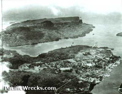 USAAF c1944 |
Location Pohnpei Island is the largest island in Pohnpei State in the Federated States of Micronesia. Roughly circular in shape measuring 129 square miles, edged with coves and jutting peninsulas. The coastline is mainly tidal flats and mangrove flats, but there are dozens of small islands. Wartime spelling "Ponape Island". Connected by a causeway to Dakatik Island (Takatik) with present day Pohnpei Airport. Also offshore is Temwen Island, Langar Island and Sepwit Island (Sepwet). Prewar Pohnpei is one of the only islands in the Pacific with ruins from every period of Micronesian history: Micronesian, Spanish and German, plus Japanese and American from the Pacific War and postwar era. Wartime History During the Pacific War, Pohnpei Island was occupied by the Japanese. During February 1944 until February 1945, attacked by American bombers and fighters. Occupied by the Japanese until the end of the Pacific War until the official surrender of Japan on September 2, 1945. American missions against Ponape February 14, 1944–February 6, 1945 Pohnpei Island (Ponape) Kolonia (Colonia) located on the northern coast of Pohnpei Island. Nan Pohn Mal Airfield located near Kolonia (Colonia) wartime airfield diused. Pohn Lher mountain overlooking Kolonia (Colonia) on Pohnpei Island. Palikir (National Government Center) located on located on the northern coast of Pohnpei Island, FSM capital. Palikir Airfield (Airfield Number 2) located at Palikir on Pohnpei Island. Kitti area to the southwest center of Pohnpei Island. Sokehs (Jokej) large rock formation on the northern end of Pohnpei Island. Kupwuriso mountain at the center of Pohnpei Island to the south of Kolonia. B-25G Mitchell 42-64832 Pilot Miller ditched March 26, 1944 roughly 15 miles north of Ponape Island, 7 missing B-25G Mitchell 42-64954 Pilot Phillips ditched March 26, 1944 roughly 20 miles north of Ponape Island, four rescued Contribute
Information Last Updated
|
| Discussion Forum | Daily Updates | Reviews | Museums | Interviews & Oral Histories |
|